
🇺🇦 Printable Map of Ukraine with Oblasts
🇺🇦 Printable Map of Ukraine with Oblasts
✅ Téléchargement gratuit – PDF et JPEG, prêts à imprimer.
Téléchargez ici une printable Map of Ukraine with Oblasts à imprimer pour l’enseignement de la géographie, les fiches d’exercices, les activités en classe, les quiz, la planification de voyages et bien plus encore.
Impossible de charger la disponibilité du service de retrait
Ajoutez plusieurs cartes à votre panier pour les télécharger toutes en même temps.
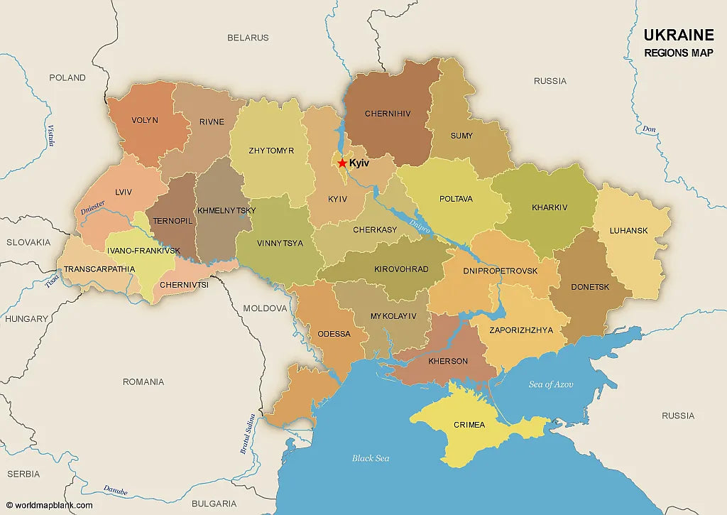
Download your free printable map of Ukraine with regions, available as a JPEG image and a PDF file!
We also offer a high-resolution political map of Ukraine with major cities.
Or get your Ukraine labeled maps bundle, including:
🗺 Printable map of Ukraine with regions (oblasts)
🗺 Map of Ukraine and Surrounding Countries (with region capitals)
🗺 Political map of Ukraine with capitals and cities
The bundle includes PDF and JPEG versions of all maps.
The maps with regions and capitals include borders and/or city markers for:
Chernihiv (Chernihiv), Chernivtsi (Chernivtsi), Dnipropetrovsk (Dnipro), Donetsk (Donetsk), Ivano-Frankivsk (Ivano-Frankivsk), Kharkiv (Kharkiv), Kherson (Kherson), Khmelnytskyi (Khmelnytskyi), Kirovohrad (Kropyvnytskyi), Kyiv (Kyiv), Luhansk (Luhansk), Lviv (Lviv), Mykolaiv (Mykolaiv), Odesa (Odesa), Poltava (Poltava), Rivne (Rivne), Sumy (Sumy), Ternopil (Ternopil), Transcarpathian (Uzhhorod), Vinnytsia (Vinnytsia), Volyn (Lutsk), Zaporizhzhia (Zaporizhzhia), Zhytomyr (Zhytomyr), Autonomous Republic of Crimea (Simferopol)
The map with cities includes additional markers for:
Kovel, Korosten, Nizhyn, Shostka, Kupiansk, Lysychansk, Mariupol, Kremenchuk, Voznesensk, Izmail, Nikopol, Melitopol, Yevpatoria, Yalta, Kerch, Sevastopol, Dzhankoy


Téléchargez votre carte gratuite
Entrez votre adresse e-mail et dites-nous comment vous comptez utiliser la carte. Le téléchargement commence immédiatement.