

Political World Map
Political World Map
✅ Gratis download – PDF en JPEG, klaar om af te drukken.
Download hier een political World Map om af te drukken voor aardrijkskunde, werkbladen, klasactiviteiten, quizzen, reisplanning en nog veel meer.
Kan beschikbaarheid voor afhalen niet laden
Voeg meer kaarten toe aan je winkelwagen om ze allemaal in één keer te downloaden.
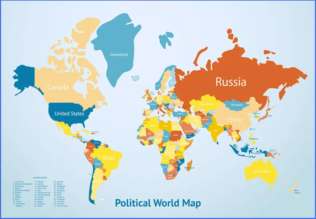
The political world map is a printable map of the world that names every country and draws every border between them, in three free versions plus a high-resolution file, as a JPG and a PDF. A political map shows the lines people drew rather than the landscape underneath, which is why it is the version classrooms use for country work.
The three free versions differ in style rather than content, so pick the one that suits the job: a strongly coloured reference map, a clean flat-design map for a display, or a detailed atlas-style map with the oceans, seas and latitude lines marked. Explore our other world maps for download, or combine this map with the printable blank world map so students can work on one and check against the other.
For a single continent or country named the same way, see our labeled continent maps and political country maps.
The image below shows the political world map with countries in the van der Grinten projection. It is also available as a jigsaw puzzle.

Which Version Should You Download?
Three versions are free and one is a paid high-resolution file. They name the same world; they look nothing like each other.
| Version | What it looks like | Best for |
|---|---|---|
| Version 1 | Strong, saturated colours on a pale background, every country named in small capitals, no ocean names | A dense reference map where the countries are the whole point |
| Version 2 | Flat design in blues, oranges and yellows, large friendly labels, a title panel and a numbered key for the smallest countries | A classroom wall or a display print that has to read from a distance |
| Version 3 | Atlas style in the van der Grinten projection, with the oceans and major seas named, the Equator, both tropics and the polar circles drawn, and a full latitude and longitude grid | Serious geography work, and the version shown above |
| High-Resolution Map | Version 3 at 3840 x 2624 pixels, supplied in PNG, JPG and PDF | Large prints, posters and anything going past A3 |
Every free version comes as both a JPG and a PDF. The high-resolution file adds PNG, which is the format to use when you need a transparent-free, lossless image for a report or a poster layout.
Why the Versions Look Different: Projections
Any flat map of a round planet has to distort something, and each projection chooses what to sacrifice.
What the van der Grinten projection does, and why Greenland keeps changing size (click to reveal)
The van der Grinten projection, published by Alphons J. van der Grinten in 1904, places the world inside a circle and curves the meridians towards the poles. It keeps continent shapes recognisable and gives a rounder, more globe-like world than a plain rectangular map, at the cost of stretching the far north and south. The National Geographic Society used it as its reference world map from 1922 until 1988, which is why the look is familiar even to people who have never heard the name.
That trade-off is why Greenland looks enormous on some maps and modest on others. Greenland covers about 2.2 million square kilometres and Africa about 30.4 million, so Africa is roughly fourteen times larger, yet on a Mercator map the two look comparable. A political map's job is to show who owns what, so a projection that keeps shapes readable matters more here than one that keeps areas exact.
The 10 Largest Countries in the World
Ten countries cover almost half the world's land between them, and the top three alone account for more than a quarter of it.
| Country | Area | Population |
|---|---|---|
| Russia | 17.1 million km2 | about 144 million |
| Canada | 10.0 million km2 | about 41 million |
| China | 9.6 million km2 | about 1.41 billion |
| United States | 9.5 million km2 | about 342 million |
| Brazil | 8.5 million km2 | about 213 million |
| Australia | 7.7 million km2 | about 27 million |
| India | 3.3 million km2 | about 1.45 billion |
| Argentina | 2.8 million km2 | about 46 million |
| Kazakhstan | 2.7 million km2 | about 20 million |
| Algeria | 2.4 million km2 | about 46 million |
Size and weight are not the same thing on a political map: India sits seventh by area but first by population, while Russia is nearly six times larger than India and holds a tenth of the people.
About the World's Borders
There are 195 countries by the usual count, the 193 members of the United Nations plus the Vatican and the Palestinian Territories, which hold observer status instead. The lines between them are recent by the standards of geography: most of Africa's borders were drawn in Europe in the 1880s, and more than thirty countries on any current map did not exist in 1990. Russia borders fourteen countries and China borders fourteen as well, more than anywhere else, while the longest border in the world runs 8,891 kilometres between Canada and the United States. A political map also has to decide what to do with the places that are not countries at all: Greenland is named with Denmark, Puerto Rico with the United States, and the world's dependencies and overseas territories appear on every version here alongside the sovereign states. Those are the facts a political map is consulted for, which is why every country on it is written out.
Political World Map Features
- Three free versions plus a high-resolution file
- Every country named and every border drawn
- Free versions in JPG and PDF; the high-resolution version adds PNG at 3840 x 2624 pixels
- Version 3 names the oceans and major seas and carries a full latitude and longitude grid
- Prints cleanly at A4 and US Letter, and scales to poster size from the high-resolution file
- Available as a 1000-piece jigsaw puzzle in the same van der Grinten projection
- Suitable for classroom use, geography lessons, study projects, reports and general reference
Frequently Asked Questions
Answers to the questions people ask most about the printable political world map.
What is a political world map?
A political map shows countries, their borders and their names. It maps the divisions people agreed on rather than the terrain, so mountains, deserts and river basins are not drawn. That is what makes it the standard map for learning where countries are and who borders whom.
What is the difference between the three free versions?
Style, not content. Version 1 is a densely coloured reference map, Version 2 is a flat-design map with large labels and a title panel that reads well from across a room, and Version 3 is an atlas-style map in the van der Grinten projection with the oceans named and a latitude and longitude grid.
What is the van der Grinten projection?
A projection published in 1904 that sets the world inside a circle and curves the meridians, giving a rounder, more globe-like map than a rectangular one. National Geographic used it as its reference world map from 1922 to 1988. It keeps continent shapes recognisable, at the cost of stretching the polar regions.
Can I print the political world map at A4 size?
Yes. Every version comes as a PDF as well as a JPG, and the PDF prints cleanly at A4 and at US Letter. For A3, a wall chart or a poster, use the high-resolution file at 3840 x 2624 pixels.
Is the political world map free to download?
Three versions are free in JPG and PDF, with no sign-up. Only the high-resolution file, which adds PNG and a much larger print size, carries a small one-off price.
How to Get Your Printable Map
- Add the version or versions you want to the cart.
- Proceed to checkout.
- Download your maps instantly, then print or annotate them.
Who It's For
Students and teachers working on countries and borders, homeschooling parents, travellers, and anyone who needs a named world map for a report, a presentation or a wall.
Download your printable political world map now and use it for learning, teaching, or reference.


Download je gratis kaart
Vul je e-mailadres in en vertel ons hoe je de kaart gaat gebruiken. Je download begint direct.