
🇩🇪 Printable Map of Germany with States
🇩🇪 Printable Map of Germany with States
✅ Gratis download – PDF en JPEG, klaar om af te drukken.
Download hier een printable Map of Germany with States om af te drukken voor aardrijkskunde, werkbladen, klasactiviteiten, quizzen, reisplanning en nog veel meer.
Kan beschikbaarheid voor afhalen niet laden
Voeg meer kaarten toe aan je winkelwagen om ze allemaal in één keer te downloaden.
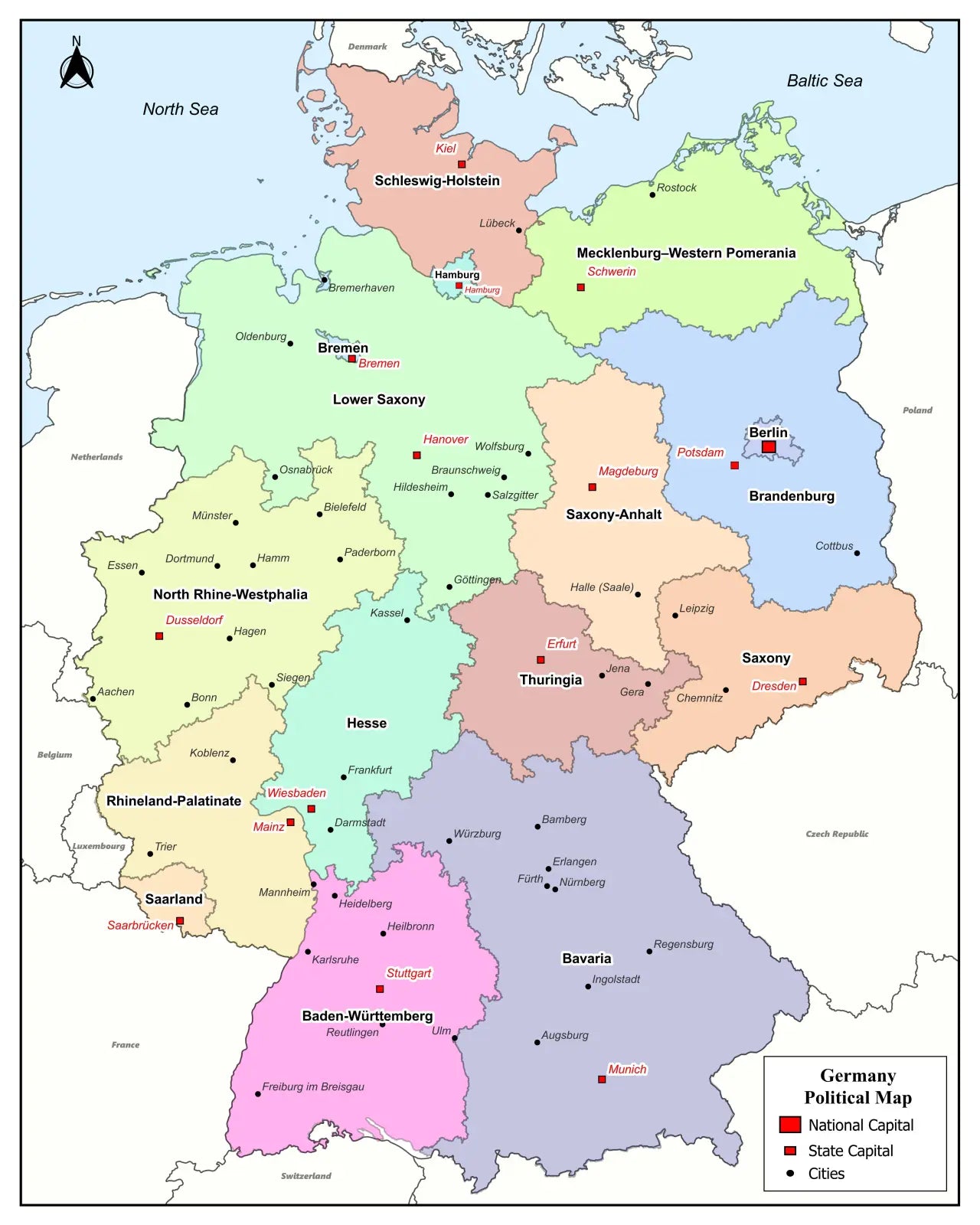
Download your free printable map of Germany with regions as a JPEG image and a PDF file!
Or buy your Germany labeled maps bundle, including:
🗺 Printable map of Germany with states
🗺 Labeled Germany map with states and state capitals
🗺 Political map of Germany with states, capitals, and major cities
🗺 Labeled map of Germany with neighboring countries
🗺 Printable Germany map with cities
The bundle includes PDF and JPEG versions of all maps.
The maps with states and capitals include borders and/or city markers for:
Baden-Württemberg (Stuttgart), Bavaria (Munich), Berlin (Berlin), Brandenburg (Potsdam), Bremen (Bremen), Hamburg (Hamburg), Hesse (Wiesbaden), Mecklenburg-Vorpommern (Schwerin), Lower Saxony (Hannover), North Rhine-Westphalia (Düsseldorf), Rhineland-Palatinate (Mainz), Saarland (Saarbrücken), Saxony (Dresden), Saxony-Anhalt (Magdeburg), Schleswig-Holstein (Kiel), and Thuringia (Erfurt)
The maps with cities also include markers for:
Aachen, Augsburg, Bamberg, Braunschweig, Bremerhaven, Chemnitz, Constance, Darmstadt, Dessau, Duisburg, Emden, Erlangen, Essen, Flensburg, Frankfurt am Main, Freiburg im Breisgau, Fürth, Göttingen, Hagen, Halle (Saale), Heidelberg, Heilbronn, Hildesheim, Ingolstadt, Jena, Karlsruhe, Kassel, Koblenz, Köln (Cologne), Lübeck, Mannheim, Mainz, Münster, Nuremberg, Oldenburg, Osnabrück, Passau, Regensburg, Reutlingen, Rostock, Saarbrücken, Salzgitter, Siegen, Trier, Ulm, Wiesbaden, Wilhelmshaven, Wolfsburg, Würzburg, and Wittenberg
For a complete Germany map collection, also check out our blank map of Germany products. Additionally, we offer ready-made Germany map worksheets based on our maps.


Download je gratis kaart
Vul je e-mailadres in en vertel ons hoe je de kaart gaat gebruiken. Je download begint direct.