
🇪🇺 Physical Map of Europe
🇪🇺 Physical Map of Europe
✅ Download gratuito – PDF e JPEG, prontos para imprimir.
Descarregue aqui um physical Map of Europe para imprimir, destinado ao ensino de geografia, fichas de exercícios, atividades para a sala de aula, questionários, planeamento de viagens e muito mais.
Não foi possível carregar a disponibilidade de retirada.
Adicione mais cartões ao seu carrinho para baixá-los todos de uma vez.
Download your free physical map of Europe as a JPG image and a PDF file!
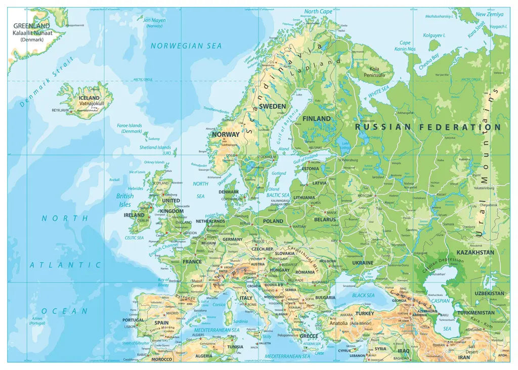
🗺 Europe physical map with mountains, rivers, countries, and cities
The download includes a PDF and a JPG version of the map.
Complete your map collection with a political map of Europe or a printable blank map of Europe. Also, check out our ready-made and customizable Europe map worksheets.
Track your European travel adventures with our Europe scratch map, or get an educational map poster featuring the EU member states.
About the physical features of the European continent:
Europe's highest mountain is Mount Elbrus, reaching 5,642 meters (18,510 feet) in the Caucasus Mountains between Russia and Georgia. The second-highest is Mont Blanc, standing at 4,808 meters (15,774 feet) in the Alps on the border of France, Italy, and Switzerland. The third highest is Monte Rosa, reaching 4,634 meters (15,203 feet), also in the Alps.
Europe's longest river is the Volga River, stretching approximately 3,530 kilometers (2,193 miles) through western Russia and flowing into the Caspian Sea. The second longest is the Danube River, measuring around 2,857 kilometers (1,775 miles) as it flows through ten countries from Germany to Romania and the Black Sea. The third longest is the Ural River, spanning roughly 2,428 kilometers (1,509 miles) between Russia and Kazakhstan.
The continent features vast plains, including the Eastern European Plain, which stretches across Russia and Eastern Europe, and the North European Plain extending from France through Germany and Poland.
The Mediterranean Sea borders southern Europe, while the North Sea, Baltic Sea, and Black Sea define other regions.
Major mountain ranges besides the Alps and Caucasus include the Pyrenees between France and Spain, the Carpathians in Central Europe, and the Scandinavian Mountains in northern Scandinavia.
The continent also contains significant fjords along Norway's western coast, dense forests in central and eastern regions, and diverse ecosystems ranging from Mediterranean scrublands to Arctic tundra.
Baixa o teu mapa gratuito
Digita seu e-mail e conta pra gente como você vai usar o mapa. O download começa imediatamente.