
🇺🇦 Printable Map of Ukraine with Oblasts
🇺🇦 Printable Map of Ukraine with Oblasts
✅ Gratis nedladdning – PDF och JPEG, redo att skriva ut.
Ladda ner en printable Map of Ukraine with Oblasts att skriva ut för geografilektioner, övningsblad, klassrumsaktiviteter, frågeformulär, resplanering och mycket mer.
Det gick inte att ladda hämtningstillgänglighet
Lägg till fler kort i varukorgen för att ladda ner dem alla på en gång.
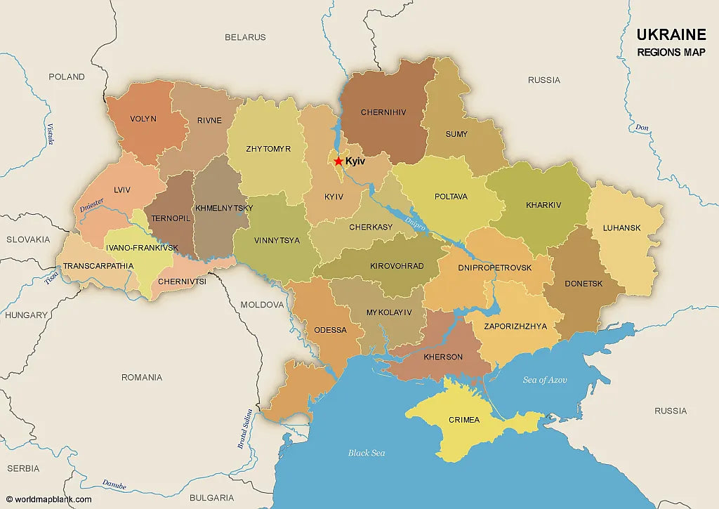
Download your free printable map of Ukraine with regions, available as a JPEG image and a PDF file!
We also offer a high-resolution political map of Ukraine with major cities.
Or get your Ukraine labeled maps bundle, including:
🗺 Printable map of Ukraine with regions (oblasts)
🗺 Map of Ukraine and Surrounding Countries (with region capitals)
🗺 Political map of Ukraine with capitals and cities
The bundle includes PDF and JPEG versions of all maps.
The maps with regions and capitals include borders and/or city markers for:
Chernihiv (Chernihiv), Chernivtsi (Chernivtsi), Dnipropetrovsk (Dnipro), Donetsk (Donetsk), Ivano-Frankivsk (Ivano-Frankivsk), Kharkiv (Kharkiv), Kherson (Kherson), Khmelnytskyi (Khmelnytskyi), Kirovohrad (Kropyvnytskyi), Kyiv (Kyiv), Luhansk (Luhansk), Lviv (Lviv), Mykolaiv (Mykolaiv), Odesa (Odesa), Poltava (Poltava), Rivne (Rivne), Sumy (Sumy), Ternopil (Ternopil), Transcarpathian (Uzhhorod), Vinnytsia (Vinnytsia), Volyn (Lutsk), Zaporizhzhia (Zaporizhzhia), Zhytomyr (Zhytomyr), Autonomous Republic of Crimea (Simferopol)
The map with cities includes additional markers for:
Kovel, Korosten, Nizhyn, Shostka, Kupiansk, Lysychansk, Mariupol, Kremenchuk, Voznesensk, Izmail, Nikopol, Melitopol, Yevpatoria, Yalta, Kerch, Sevastopol, Dzhankoy


Ladda ner din gratis karta
Ange din e-postadress och berätta hur du tänker använda kartan. Nedladdningen påbörjas omedelbart.