
🇨🇦 Labeled Map of Canada with Provinces
🇨🇦 Labeled Map of Canada with Provinces
✅ Download gratuito – PDF e JPEG, pronti per la stampa.
Scarica qui una labeled Map of Canada with Provinces da stampare per l’insegnamento della geografia, fogli di esercizi, attività da svolgere in classe, questionari, programmi di viaggio e molto altro ancora.
Impossibile caricare la disponibilità di ritiro
Aggiungi altre mappe al carrello per scaricarle tutte in una volta.
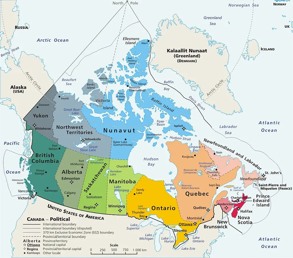
Download your free labeled map of Canada with provinces or a printable political map of Canada as a JPG image and a PDF file!
We also offer a high-resolution map of Canada (4000 x 4889 px) with provinces, capitals, major cities, and neighboring countries.
Or get your labeled Canada maps bundle, including:
🗺 Canada Map with Cities
🗺 Map of Canada with Provinces
🗺 Political map of Canada with Capitals
🗺 Canada Reference Map
All variants include PDF and JPG versions.
The map with provinces and capitals includes borders and city markers for:
Alberta (Edmonton), British Columbia (Victoria), Manitoba (Winnipeg), New Brunswick (Fredericton), Newfoundland and Labrador (St. John’s), Northwest Territories (Yellowknife), Nova Scotia (Halifax), Nunavut (Iqaluit), Ontario (Toronto), Prince Edward Island (Charlottetown), Quebec (Quebec City), Saskatchewan (Regina), Yukon (Whitehorse)
The map with cities additionally includes:
Alert, Cambridge Bay, Cape Dorset, Chisasibi, Corner Brook, Dawson City, Fort Good Hope, Fort Resolution, Fort Smith, Gander, Goose Bay, Hay River, Inuvik, Iqaluktuuttiaq, Kangirsuk, Kangirsujuaq, Kuujjuaq, Kuujjuarapik, Labrador City, La Ronge, Lethbridge, Meadow Lake, Moncton, Moose Jaw, Nanaimo, Nelson, North Bay, Prince Rupert, Rankin Inlet, Red Deer, Rouyn-Noranda, Saguenay, Saskatoon, Sept-Îles, Sherbrooke, St. Anthony, Sudbury, Thompson, Trois-Rivières, Val-d’Or, Whitecourt, Yellowknife Bay


Scarica la mappa gratuita
Inserisci il tuo indirizzo e-mail e dicci come intendi utilizzare la mappa. Il download inizierà immediatamente.