
🇩🇪 Printable Map of Germany with States
🇩🇪 Printable Map of Germany with States
✅ Download gratuito – PDF e JPEG, pronti per la stampa.
Scarica qui una printable Map of Germany with States da stampare per l’insegnamento della geografia, fogli di esercizi, attività da svolgere in classe, questionari, programmi di viaggio e molto altro ancora.
Impossibile caricare la disponibilità di ritiro
Aggiungi altre mappe al carrello per scaricarle tutte in una volta.
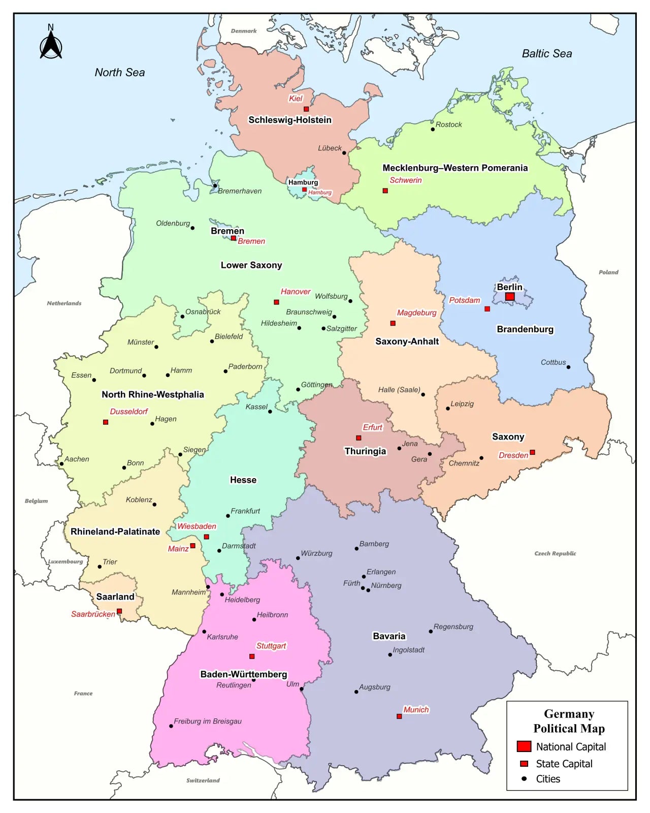
Download your free printable map of Germany with regions as a JPEG image and a PDF file!
Or buy your Germany labeled maps bundle, including:
🗺 Printable map of Germany with states
🗺 Labeled Germany map with states and state capitals
🗺 Political map of Germany with states, capitals, and major cities
🗺 Labeled map of Germany with neighboring countries
🗺 Printable Germany map with cities
The bundle includes PDF and JPEG versions of all maps.
The maps with states and capitals include borders and/or city markers for:
Baden-Württemberg (Stuttgart), Bavaria (Munich), Berlin (Berlin), Brandenburg (Potsdam), Bremen (Bremen), Hamburg (Hamburg), Hesse (Wiesbaden), Mecklenburg-Vorpommern (Schwerin), Lower Saxony (Hannover), North Rhine-Westphalia (Düsseldorf), Rhineland-Palatinate (Mainz), Saarland (Saarbrücken), Saxony (Dresden), Saxony-Anhalt (Magdeburg), Schleswig-Holstein (Kiel), and Thuringia (Erfurt)
The maps with cities also include markers for:
Aachen, Augsburg, Bamberg, Braunschweig, Bremerhaven, Chemnitz, Constance, Darmstadt, Dessau, Duisburg, Emden, Erlangen, Essen, Flensburg, Frankfurt am Main, Freiburg im Breisgau, Fürth, Göttingen, Hagen, Halle (Saale), Heidelberg, Heilbronn, Hildesheim, Ingolstadt, Jena, Karlsruhe, Kassel, Koblenz, Köln (Cologne), Lübeck, Mannheim, Mainz, Münster, Nuremberg, Oldenburg, Osnabrück, Passau, Regensburg, Reutlingen, Rostock, Saarbrücken, Salzgitter, Siegen, Trier, Ulm, Wiesbaden, Wilhelmshaven, Wolfsburg, Würzburg, and Wittenberg
For a complete Germany map collection, also check out our blank map of Germany products. Additionally, we offer ready-made Germany map worksheets based on our maps.


Scarica la mappa gratuita
Inserisci il tuo indirizzo e-mail e dicci come intendi utilizzare la mappa. Il download inizierà immediatamente.