
🇺🇦 Printable Map of Ukraine with Oblasts
🇺🇦 Printable Map of Ukraine with Oblasts
✅ Free download – PDF and JPEG, ready to print.
Download a printable map of Ukraine with oblasts for geography teaching, practice worksheets, classroom exercises, homeschooling, presentations, travel planning, and more.
Couldn't load pickup availability
Add multiple maps to the cart to download them all at once.
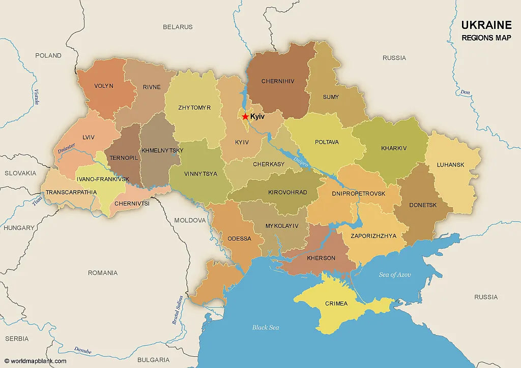
Download your free printable map of Ukraine with regions, available as a JPEG image and a PDF file!
We also offer a high-resolution political map of Ukraine with major cities.
Or get your Ukraine labeled maps bundle, including:
🗺 Printable map of Ukraine with regions (oblasts)
🗺 Map of Ukraine and Surrounding Countries (with region capitals)
🗺 Political map of Ukraine with capitals and cities
The bundle includes PDF and JPEG versions of all maps.
The maps with regions and capitals include borders and/or city markers for:
Chernihiv (Chernihiv), Chernivtsi (Chernivtsi), Dnipropetrovsk (Dnipro), Donetsk (Donetsk), Ivano-Frankivsk (Ivano-Frankivsk), Kharkiv (Kharkiv), Kherson (Kherson), Khmelnytskyi (Khmelnytskyi), Kirovohrad (Kropyvnytskyi), Kyiv (Kyiv), Luhansk (Luhansk), Lviv (Lviv), Mykolaiv (Mykolaiv), Odesa (Odesa), Poltava (Poltava), Rivne (Rivne), Sumy (Sumy), Ternopil (Ternopil), Transcarpathian (Uzhhorod), Vinnytsia (Vinnytsia), Volyn (Lutsk), Zaporizhzhia (Zaporizhzhia), Zhytomyr (Zhytomyr), Autonomous Republic of Crimea (Simferopol)
The map with cities includes additional markers for:
Kovel, Korosten, Nizhyn, Shostka, Kupiansk, Lysychansk, Mariupol, Kremenchuk, Voznesensk, Izmail, Nikopol, Melitopol, Yevpatoria, Yalta, Kerch, Sevastopol, Dzhankoy


Download your free map
Enter your email and tell us how you'll use the map. Your download starts immediately.