

Labeled World Map
Labeled World Map
✅ Free download – PDF and JPEG, ready to print.
Download a printable Labeled world map for geography teaching, practice worksheets, classroom exercises, homeschooling, presentations, travel planning, and more.
Couldn't load pickup availability
Add multiple maps to the cart to download them all at once.
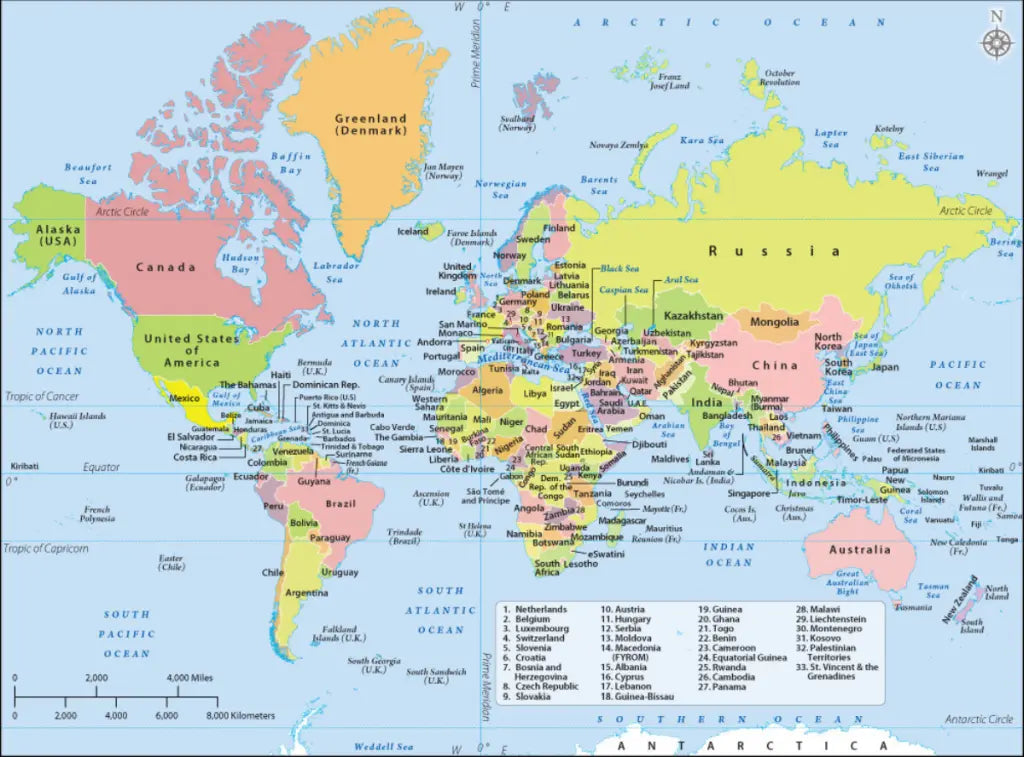
The labeled world map is a printable political map that names every country on Earth, with the 33 smallest listed in a numbered key, and it downloads free as a PDF and a JPEG in two versions, sized for A4 and printing on US Letter.
Everything on the map is written out: countries, dependencies with the country they belong to in brackets, the oceans and the major seas, the Equator, both tropics, the Arctic and Antarctic Circles, the Prime Meridian and a scale bar in miles and kilometres. That makes it a reference sheet rather than an exercise. When you want a version to fill in yourself, take the printable blank world map instead, or pair the two: one to work from, one to check against.
It pairs well with our geography worksheets. For other projections and a high-resolution file, see the political world map, and for continents rather than countries, the world map with continents.
The image below shows the printable labeled world map with every country named.

Which Version Should You Download?
Both versions are free, they use the same projection and they name the same places. The differences are in the colours and in two details worth knowing before you print.
| Version | What is different |
|---|---|
| Version 1 | Strong, saturated colours and a "World Map" title box in the top left. Its numbered key uses the current country names, Czechia and North Macedonia |
| Version 2 | Softer pastel colours and a compass rose in the top right instead of a title box. Its key uses the older names, Czech Republic and Macedonia (FYROM) |
Version 1 is the safer classroom print because its naming is current. North Macedonia dropped the FYROM name in 2019.
What the Map Names
Small countries are too small to letter at world scale, so 33 of them carry a number on the map and are named in a key in the South Atlantic. These are the ones people most often cannot place.
Show the 33 numbered countries in the key (click to reveal)
| No. | Country | No. | Country |
|---|---|---|---|
| 1 | Netherlands | 18 | Guinea-Bissau |
| 2 | Belgium | 19 | Guinea |
| 3 | Luxembourg | 20 | Ghana |
| 4 | Switzerland | 21 | Togo |
| 5 | Slovenia | 22 | Benin |
| 6 | Croatia | 23 | Cameroon |
| 7 | Bosnia and Herzegovina | 24 | Equatorial Guinea |
| 8 | Czechia | 25 | Rwanda |
| 9 | Slovakia | 26 | Cambodia |
| 10 | Austria | 27 | Panama |
| 11 | Hungary | 28 | Malawi |
| 12 | Serbia | 29 | Liechtenstein |
| 13 | Moldova | 30 | Montenegro |
| 14 | North Macedonia | 31 | Kosovo |
| 15 | Albania | 32 | Palestinian Territories |
| 16 | Cyprus | 33 | St. Vincent and the Grenadines |
| 17 | Lebanon |
Twenty of the 33 are in Europe or West Africa, the two parts of the world where the most countries are packed into the least space.
The map names countries, not capitals: there are no city markers on it, so it answers "which country is that" rather than "what is its capital".
About the Countries of the World
There are 195 countries by the usual count, the 193 members of the United Nations plus the Vatican and the Palestinian Territories, both of which hold observer status rather than membership. Dozens more places appear on a world map without being countries at all: Greenland is named with Denmark in brackets, Puerto Rico with the United States, the Falkland Islands with the United Kingdom, and this map marks every one of them the same way. Russia is the largest country at about 17 million square kilometres, spread across eleven time zones and two continents, while the Vatican is the smallest at less than half a square kilometre, which is why it appears here as a leader line rather than a shape. Canada has the longest coastline of any country, at roughly 202,000 kilometres, and China and India between them hold more people than the whole of Africa and Europe combined. Those are the facts a named world map is usually consulted for, which is why every country on this one is written out rather than left to be guessed.
Labeled World Map Features
- Two free versions in high-resolution PDF and JPEG
- Every country named, with 33 small countries numbered and listed in a key
- Dependencies named with the country they belong to in brackets
- Oceans and major seas named, on both sides of the map
- Equator, Tropics of Cancer and Capricorn, Arctic and Antarctic Circles and the Prime Meridian marked
- Scale bar in both miles and kilometres
- Sized for A4 and prints on US Letter without cropping
- Suitable for classroom reference, homework, wall displays and travel planning
Frequently Asked Questions
Answers to the questions people ask most about the free labeled world map.
Does the labeled world map show capital cities?
No. It names countries, dependencies, oceans and seas, but it marks no cities at all, capitals included. It is a country reference map rather than a city map.
What is the difference between the two versions?
They are the same map in different colours. Version 1 is strongly coloured, carries a title box and uses the current names Czechia and North Macedonia. Version 2 is pastel, carries a compass rose and still uses Czech Republic and Macedonia (FYROM) in its key.
How many countries are named on the map?
All of them. 195 countries are recognised by the usual count, and the 33 that are too small to letter at this scale are numbered on the map and named in a key in the South Atlantic. Dependencies are named too, with their parent country in brackets.
Can I print the labeled world map in A4 size?
Yes, both files are sized for A4 and print on US Letter without cropping. The country names are small at A4, so print the PDF at A3 or larger if it is going on a wall.
Is the labeled world map free to download?
Yes. Both versions are free in PDF and JPEG, with no sign-up and no watermark.
How to Get Your Printable Map
- Choose the version you want above.
- Click "Download now".
- Get your files instantly, then print or annotate them.
Who It's For
Students checking their answers, teachers who need a reference copy on the wall, homeschooling parents, and travellers marking where they have been.
Download your labeled world map now and use it for learning, geography reference, or your own map projects.

Download your free map
Enter your email and tell us how you'll use the map. Your download starts immediately.