
🇩🇪 Printable Map of Germany with States
🇩🇪 Printable Map of Germany with States
✅ Free download – PDF and JPEG, ready to print.
Download a printable map of Germany with states for geography teaching, practice worksheets, classroom exercises, homeschooling, presentations, travel planning, and more.
Couldn't load pickup availability
Add multiple maps to the cart to download them all at once.
Download your free printable map of Germany with regions as a JPEG image and a PDF file!
Or buy your Germany labeled maps bundle, including:
🗺 Printable map of Germany with states
🗺 Labeled Germany map with states and state capitals
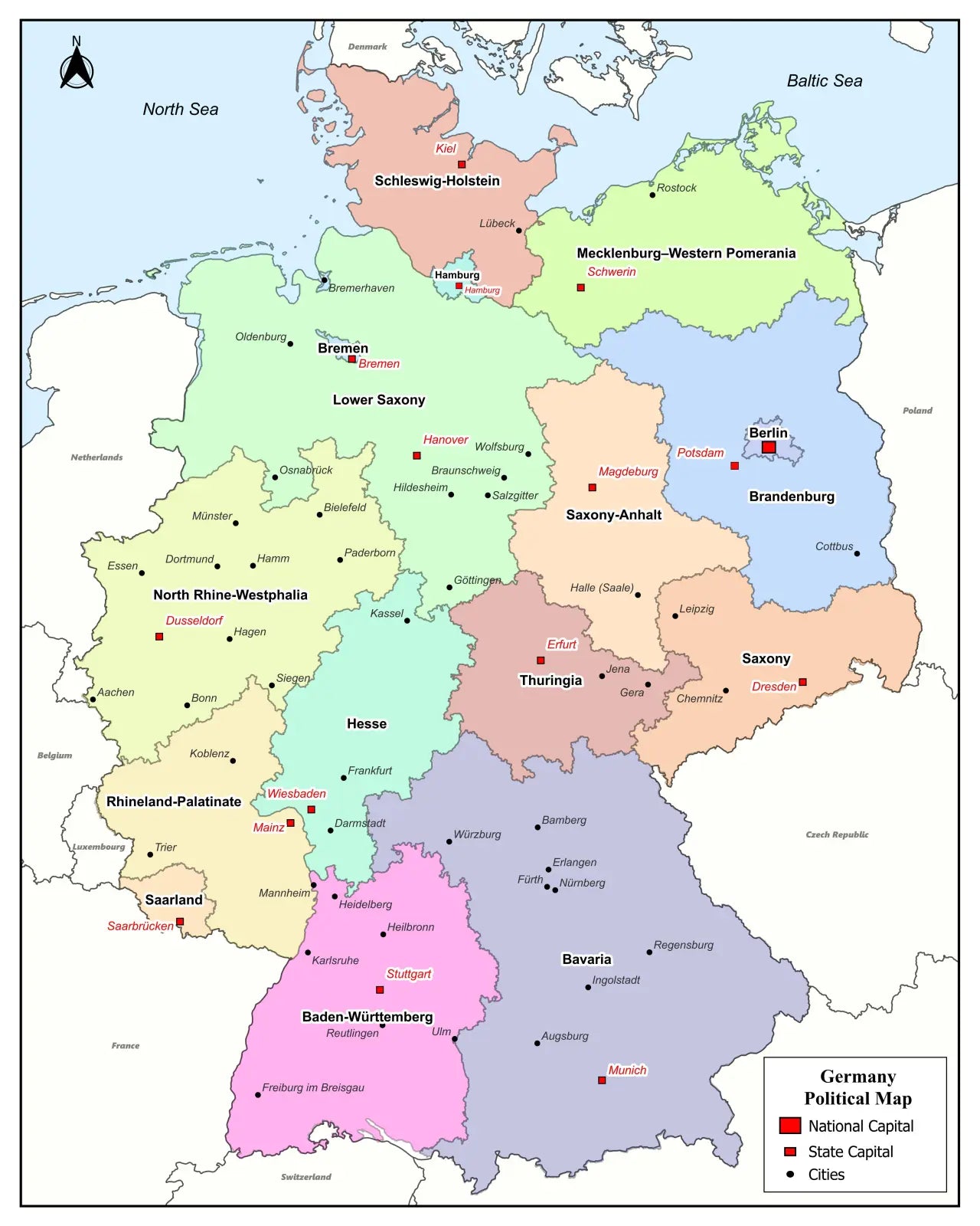
🗺 Political map of Germany with states, capitals, and major cities
🗺 Labeled map of Germany with neighboring countries
🗺 Printable Germany map with cities
The bundle includes PDF and JPEG versions of all maps.
The maps with states and capitals include borders and/or city markers for:
Baden-Württemberg (Stuttgart), Bavaria (Munich), Berlin (Berlin), Brandenburg (Potsdam), Bremen (Bremen), Hamburg (Hamburg), Hesse (Wiesbaden), Mecklenburg-Vorpommern (Schwerin), Lower Saxony (Hannover), North Rhine-Westphalia (Düsseldorf), Rhineland-Palatinate (Mainz), Saarland (Saarbrücken), Saxony (Dresden), Saxony-Anhalt (Magdeburg), Schleswig-Holstein (Kiel), and Thuringia (Erfurt)
The maps with cities also include markers for:
Aachen, Augsburg, Bamberg, Braunschweig, Bremerhaven, Chemnitz, Constance, Darmstadt, Dessau, Duisburg, Emden, Erlangen, Essen, Flensburg, Frankfurt am Main, Freiburg im Breisgau, Fürth, Göttingen, Hagen, Halle (Saale), Heidelberg, Heilbronn, Hildesheim, Ingolstadt, Jena, Karlsruhe, Kassel, Koblenz, Köln (Cologne), Lübeck, Mannheim, Mainz, Münster, Nuremberg, Oldenburg, Osnabrück, Passau, Regensburg, Reutlingen, Rostock, Saarbrücken, Salzgitter, Siegen, Trier, Ulm, Wiesbaden, Wilhelmshaven, Wolfsburg, Würzburg, and Wittenberg
For a complete Germany map collection, also check out our blank map of Germany products. Additionally, we offer ready-made Germany map worksheets based on our maps.


Download your free map
Enter your email and tell us how you'll use the map. Your download starts immediately.