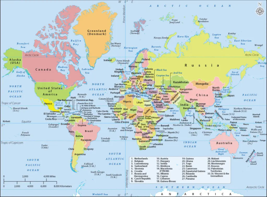
Skip to content

Labeled Map of the World – Map of the World Labeled [PDF]

Labeled Map of the World

Labeled Map of World

Download as PDF

Here on this page, you’ll find a labeled map of the world for free download in PDF. You can save and print your map of the world labeled as many times as you need. Click on the link below the desired picture of the labeled world map to get your map.

Our first map is a map of the world with countries labeled. This is a political map of the world showing the names of the countries on planet Earth as well as the oceans and seas.

We also provide various other world maps based on different topics, such as a blank world map or a world map with oceans and seas, a world map for kids, and a political world map.

For teaching your kids or students about the geography of the world, consider taking a look at our ready-made and fully customizable world map worksheets!

Map of the World Labeled

The following map is a world labeled map with the seven continents and the oceans. Just click on the download link below the image to save the map as a PDF file or print it immediately.

Labeled World Map with Continents

Download as PDF

If you need a map of a particular continent, we provide continent maps for Africa, North America, South America, Europe, Asia, Australia, and Antarctica. We also offer a world map with continents and a blank world map.

Labeled World Map With Countries

Here is another map of the world with the countries labeled.

Labeled World Map with Countries

Download as PDF

How Many Countries Are There in the World?

As of 2022, there are 195 sovereign countries in the world. However, this number is constantly changing, and there are disputes about what makes an independent country. For instance, while some countries recognize Taiwan as a sovereign state, even the United Nations officially regards it as a province of China.

What Are the Largest Countries in the World?

Here is a list of the 10 major countries in the world by land area and population (as of 2022).

10 Largest Countries in the World by Land Area

  1. Russia – 6.3 million mi² (16.4 million km²)
  2. China – 3.6 million mi² (9.4 million km²)
  3. United States of America – 3.53 million mi² (9.15 million km²)
  4. Canada – 3.51 million mi² (9.1 million km²)
  5. Brazil – 3.2 million mi² (8.4 million km²)
  6. Australia – 2.97 million mi² (7.7 million km²)
  7. India – 1.15 million mi² (2.97 million km²)
  8. Argentina – 1.06 million mi² (2.7 million km²)
  9. Kazakhstan – 1.04 million mi² (2.7 million km²)
  10. Algeria – 0.92 million mi² (2.38 million km²)

10 Largest Countries in the World by Population

  1. China – 1.425 billion
  2. India – 1.417 billion
  3. United States of America – 338 million
  4. Indonesia – 275 million
  5. Pakistan – 236 million
  6. Nigeria – 218 million
  7. Brazil – 215 million
  8. Bangladesh – 171 million
  9. Russia – 145 million
  10. Mexico – 128 million

While China is still at the top of this list, India is expected to take over the first position soon. The total number of humans on planet Earth has reached 8 billion. The UN expects the global population to grow to 9.7 billion by 2050 and over 10 billion by 2100.

According to the United Nations, the highest annual population growth is recorded in Moldova (6.91%) and Poland (4.04%). But also African countries such as Niger (3.78%), DR Congo (3.25%) or Chad (3.16%) have high population growth rates. Countries like Japan (-0.53%) and Italy (-0.34%) have a slightly decreasing population.

More Maps of the World, Continents, and Countries

Below is a list of other useful maps of the world, its continents, and countries. Check them out and get your free printable maps as PDF files.

Continent Maps

World Maps

Country Maps

Back To Top
Search
×