

🇦🇺 Labeled Political Map of Australia
🇦🇺 Labeled Political Map of Australia
✅ Free download – PDF and JPEG, ready to print.
Download a printable labeled political map of Australia for geography teaching, practice worksheets, classroom exercises, homeschooling, presentations, travel planning, and more.
Couldn't load pickup availability
Add multiple maps to the cart to download them all at once.
The labeled map of Australia is a set of five free political maps that name all six states and both mainland territories, mark every capital city, and between them name more than a hundred other cities and towns, sized for A4 and printing on US Letter. All five are free as a PDF and a JPEG.
Because everything on them is named, they work as a reference rather than an exercise: a wall chart for the classroom, a base for planning a route across the country, or the answer key alongside a quiz. If you want the version students fill in themselves, use the blank map of Australia, which is the one to download for map tests and homework.
For the whole picture, the labeled world map puts Australia in context, or browse the other printable country maps.
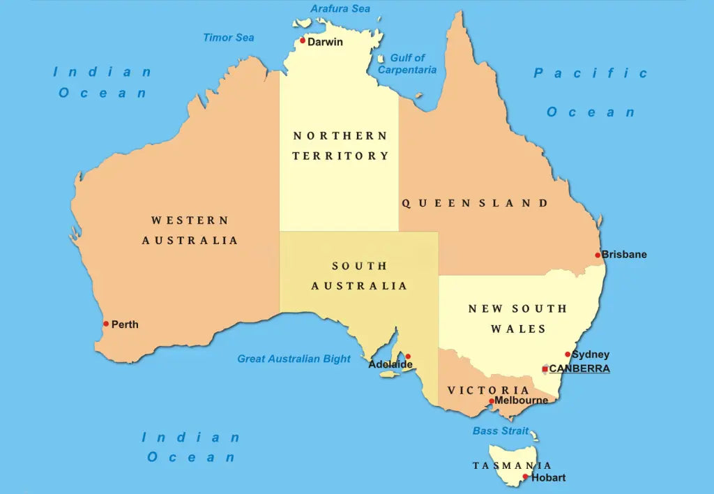
The image below shows the political version with the states and territories named, the capitals marked and the road network drawn across the country.

The Five Free Versions
All five are free, and they are genuinely different maps rather than five colours of the same one. The names are close together, so here is what each one actually gives you:
| Version | What it shows | Best for |
|---|---|---|
| Labeled map of Australia with states | All eight states and territories colour-coded with a key, national and state capitals marked separately, major cities, north arrow and a scale bar in miles and kilometres | The all-rounder: classroom wall charts and homework |
| Political map of Australia with states and territories | The same states and territories plus the road network, the big deserts, the salt lakes and the Great Barrier Reef | Route planning and anything that needs the roads |
| Political Australia map with states | States and territories named, capitals only, nothing else on the sheet | The cleanest one: reading across a room, or a simple reference |
| Labeled map of Australia with cities | No state borders at all, just cities in three sizes: the national capital, major cities and 104 towns | Learning where places are without the state lines in the way |
| Australia map labeled | A full reference sheet: terrain, mountain ranges, deserts, lakes, rivers, national parks, airports, sea ports, rail lines, a latitude and longitude grid, and an inset naming the overseas territories | Older students and anyone who wants the detail |
All of them come as PDF and JPEG files.
The 6 States and 2 Territories of Australia
Australia is divided into six states and two mainland territories, and the distinction is real rather than cosmetic: states have their own constitutions and powers of their own, while territories are ultimately governed under federal law. All eight are named on the maps that carry borders.
| State or territory | Capital | Area (km²) | Population |
|---|---|---|---|
| Western Australia | Perth | 2,527,013 | 2.9 million |
| Queensland | Brisbane | 1,730,648 | 5.6 million |
| Northern Territory | Darwin | 1,349,129 | 255,000 |
| South Australia | Adelaide | 983,482 | 1.9 million |
| New South Wales | Sydney | 800,642 | 8.5 million |
| Victoria | Melbourne | 227,444 | 7.0 million |
| Tasmania | Hobart | 68,401 | 575,000 |
| Australian Capital Territory | Canberra | 2,358 | 470,000 |
The areas are fixed; the population figures are rounded and move slowly. That table contains the fact people get wrong most often: Canberra is the capital of Australia, not Sydney and not Melbourne, and the Australian Capital Territory exists only because the two of them could not agree in 1908. It was carved out of New South Wales as neutral ground, which is why it sits inland as a small square-ish shape surrounded entirely by another state. The other extreme is Western Australia, a third of the continent on its own and larger than every country in the European Union combined, with fewer people in it than Sydney.
Show the 104 cities and towns named on the city version (click to reveal)
Adelaide, Albany, Alice Springs, Augusta, Bairnsdale, Balladonia, Bamaga, Barrow, Barrow Creek, Bathurst, Bendigo, Birdsville, Blackall, Borroloola, Brisbane, Broken Hill, Broome, Bundaberg, Bunbury, Burketown, Cairns, Canberra, Canterbury, Carnarvon, Charleville, Cobar, Collier Bay, Collinsville, Cooktown, Coober Pedy, Cooma, Cunnamulla, Darwin, Denham, Derby, Devonport, Dongara, Dubbo, Emerald, Eneabba, Erldunda, Esperance, Eucla, Exmouth, Fitzroy Crossing, Geelong, Geraldton, Gladstone, Gold Coast, Grafton, Greenvale, Hobart, Innisfail, Israelite Bay, Kalgoorlie, Kalbarri, Karratha, Katherine, Lagrange, Laverton, Lombardina, Longreach, Mackay, Meekatharra, Melbourne, Mildura, Mindil Beach, Mount Gambier, Mount Isa, Mount Magnet, Newcastle, Newman, Normanton, Norseman, Northam, Oodnadatta, Penong, Perth, Port Augusta, Port Hedland, Port Lincoln, Port Macquarie, Port Warrender, Portland, Queenstown, Rawlinna, Rockhampton, Rockingham, St. George, Sydney, Tennant Creek, Townsville, Uluru, Wagga Wagga, Warburton, Weipa, Whyalla, Wiluna, Windorah, Winton, Wittenoom, Wollongong, Wyndham and Yuendumu.
The list runs a long way past the state capitals on purpose. Australia is mostly empty in the middle, so a map that names only the eight capitals leaves 90 percent of the continent blank, and places like Coober Pedy, Birdsville and Tennant Creek are the ones that make the interior legible.
About Australia and Its States
Australia covers about 7.69 million square kilometres, which makes it the sixth largest country and the smallest continent at the same time, and it is the only country that is a whole continent of its own. Roughly 27 million people live there, and about 85 percent of them within 50 kilometres of the coast, which is the single fact that explains the shape of every population map of the country. The Great Dividing Range runs some 3,500 kilometres down the eastern edge and holds Mount Kosciuszko, the highest point on the mainland at 2,228 metres, low enough that Australia is the flattest inhabited continent. Lake Eyre in South Australia is the lowest point at about 15 metres below sea level and is dry most years. The Murray is the longest river at around 2,508 kilometres and joins the Darling in the system that drains the south-east, while the interior belongs to the Great Sandy, Gibson, Great Victoria, Tanami and Simpson Deserts and the Nullarbor Plain. Offshore, the Great Barrier Reef runs about 2,300 kilometres along the Queensland coast and is the largest coral reef system on earth. Australia has no land borders at all, which is why its map is one of the easiest in the world to recognise and one of the hardest to fill in from memory.
Labeled Map of Australia Features
- Five free versions in high-resolution PDF and JPEG
- Sized for A4 and prints on US Letter without cropping
- All six states and both mainland territories named and colour-coded
- Canberra marked as the national capital with its own symbol, separate from the state capitals
- 104 cities and towns named on the city version, in three sizes so the hierarchy reads
- Road network on the political version, for route planning rather than just reference
- Deserts, salt lakes, mountain ranges, national parks, airports and sea ports on the reference version
- Great Barrier Reef, Nullarbor Plain, Gulf of Carpentaria and the Great Australian Bight named
- An inset naming the overseas territories, which most maps of Australia leave off
- North arrow and scale bars in both miles and kilometres
- Suitable for classroom wall charts, reference, trip planning, homework and school projects
Frequently Asked Questions
Answers to the questions people ask most about the labeled map of Australia.
What is the capital of Australia?
Canberra, not Sydney and not Melbourne. It was purpose-built inland as a compromise after those two cities spent years arguing over which should be the capital, and the Australian Capital Territory was cut out of New South Wales to hold it. On these maps Canberra carries its own symbol so it is not mistaken for a state capital.
How many states and territories does Australia have?
Six states, New South Wales, Queensland, South Australia, Tasmania, Victoria and Western Australia, plus two mainland territories, the Northern Territory and the Australian Capital Territory. That is why the answer is eight and not six, and why "how many states" is a slightly unfair question.
Which version should I download?
The one with the states and the key is the all-rounder. Take the plain states version if you want the least on the page, the road version for planning a route, the city version if you need the towns rather than the borders, and the full reference version if you want the deserts, ranges, rivers and national parks as well. All five are free, so taking two costs nothing.
Does the map show Australian cities?
Yes. Every version marks the capitals, and the city version names 104 places in all, from Sydney, Melbourne and Perth down to Coober Pedy, Birdsville and Yuendumu. The full list is above.
Can I print the map of Australia in A4 size?
Yes, every file is sized for A4 and prints on US Letter without cropping. The PDF keeps its line quality when enlarged, so the same download also works for a poster-size print or a classroom wall chart.
How to Get Your Printable Map
- Choose the version you want above.
- Click "Download now" for any of the five maps.
- Get your files instantly, then print or annotate them.
Who It's For
Teachers building classroom wall charts and reference sheets, students checking their own answers, travellers planning a route across the country, and anyone who needs a clean labeled map of Australia for a project.
Download your labeled map of Australia now and use it for learning, reference, or your own map projects.


Download your free map
Enter your email and tell us how you'll use the map. Your download starts immediately.