Nile River Map Printable Labeled | Nile River on Africa Map
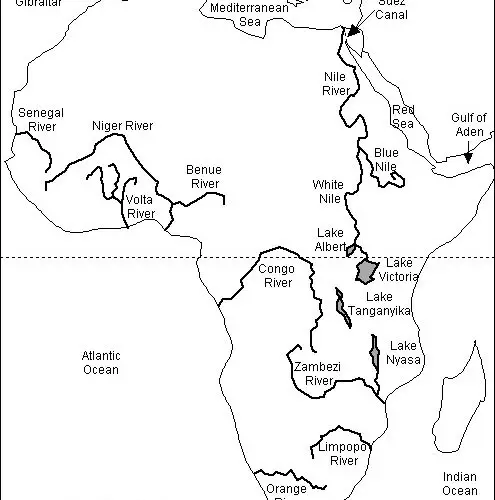
The Nile River Map is beneficial for students and researchers to find the route of the Nile River and its tributaries. The Nile River is a major river in northeastern Africa and it flows into the Mediterranean Sea. It is about 4130 miles long. Its drainage basin covers the Democratic Republic of the Congo, Tanzania, Burundi, Rwanda, Uganda, Kenya, Ethiopia, Eritrea, South Sudan, Republic of Sudan, and Egypt among the eleven countries.
Nile River Map

It is about 3,254,555 square kilometers or 10% of Africa. Its main stem depends on the various types of weather conditions. Additionally, its weather conditions include evaporation, diversions, and groundwater flow. Furthermore, it serves as the main source of water for Egypt, Sudan, and South Sudan. Here we are providing the Nile River map.
Nile River Map Labeled
The Nile River includes its two major tributaries, the White Nile, and the Blue Nile. Although the White Nile serves as a headwater stream, the Blue Nile is the source of most of the water in the Nile. Furthermore, it consists of 80% water and silt. The White Nile starts at Lake Victoria and passes through Uganda and South Sudan.
The Blue Nile starts at Lake Tana in Ethiopia and reaches into Sudan from the southeast. It travels about 900 miles. Both rivers meet at Khartoum. Although there is a dispute between its sources, the Kagera River is the main source of the White Nile. Furthermore, the Kagera River has two tributaries, which are the Ruvyironza River and the Rurubu River. Here we are providing the Nile River map.
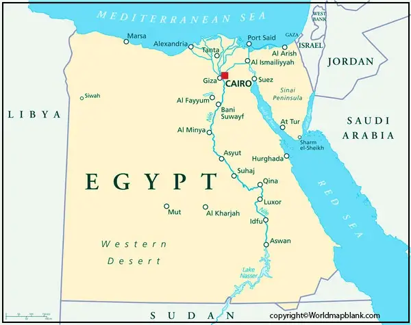
Where is the Nile River on a Map
The Abarth is also one of the major tributaries of the Nile River. It is also known as the “Red Nile River.” It originates in Ethiopia and is about 800 kilometers. Moreover, it flows during rain in Ethiopia and dries frequently. Its level rises 18 ft above its normal level. In the context of its discharge, the Bahr al Ghazal and the Sobat River are both significant tributaries of the White Nile.
The Bahr al Ghazal measures 520,000 square kilometers and contributes a small amount of water. The Sobat River drains 86900 square miles and contributes 412 cubic meters of water. The Yellow Nile is also its tributary and flows through Gharb Darfur and reaches into the Nile. Here we are providing the Nile River map.
Nile River on Africa map
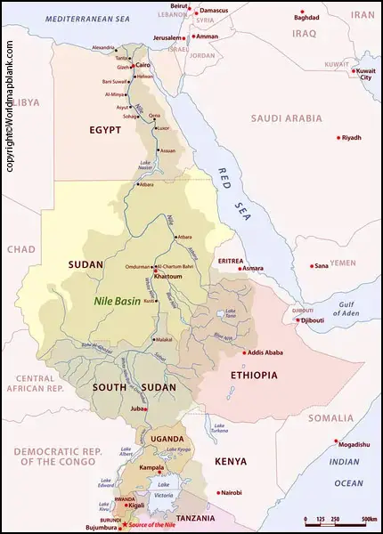
The Nile River had a significant role in Egyptian civilization. It deposits a new layer of slit and makes the land fertile, which is beneficial for cultivation. It also had an impact on the spiritual life of Egyptians. Moreover, it was a good source for transportation of goods and people. In Uganda, the While Nile flows from Lake Victoria at Ripon Falls. It flows about 81 miles long to Lake Kyoga.
It also flows into South Sudan and is known as Bahr Al Jabal. It is a political issue for East Africa and the Horn of Africa. The Nile River water sources are beneficial in evaluating upcoming conflicts regarding sharing its water. It also plays a huge role in social development.
Related Posts