Labeled Map of Mauritania with States, Capital & Cities
Labeled Map of Mauritania shows that it is a country located in Northwest Africa. Besides, Mauritania is bordering the North Atlantic coast in the west. Since most of the country is covered by the Shar Desert, it is populated sparsely. The labeled map of Mauritania also reveals about its surrounding countries, depicting international borders.
- World map with continents
- Physical world map
- Political world map
- Labeled map of Asia
- Labeled map of Africa
- Labeled map of Europe
- Labeled map of Antarctica
- Labeled map of South America
- World time zone map
- Labeled map of World
- World map with Latitude
- Blank map of world
- Labeled map of North America
- Blank map of Asia
- World map with oceans
- World map poster
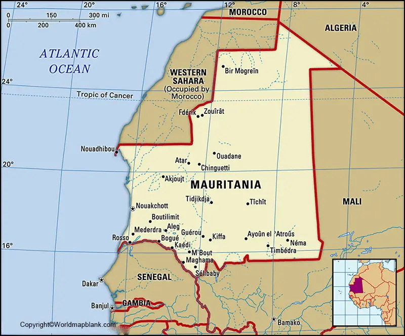
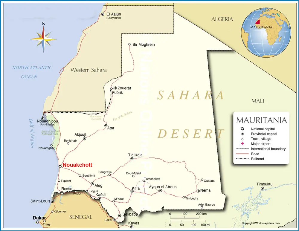
Labeled Map of Mauritania
From the map, it is also possible to identify the national capital, Nouakchott, Mauritania’s only railroad and major airports, other major cities and main roads, and province capitals. Countries like Mali, Algeria, Senegal, and Western Sahara occupied by Morocco are recognized as border countries of Mauritania. Regarding the area of the country, it appears to be about two times the size of Spain or slightly larger than the US state of Texas and New Mexico, when combined together.

As on Monday, August 31, 2020, the current population of Mauritania stood at 4,668,769 people. It is equivalent to 0.06% of the total global population. The total area of the country is measured as 1.03 square kilometers. River Senegal is the only major river of Mauritania and is the only river that flows through the nation all-round the year. Other names of the rivers that flow in the country, include Gorgol River, Karakoro River, and Kolimbine River. Most of the people living in Mauritania are Sunni Muslims.
Labeled Map of Mauritania with State
As a part of the labeled map of Mauritania with states, the country is divided into twelve wilayahs and one capital district in Nouakchott. This is further subdivided into forty-four mouaghataas of Mauritania. In Mauritania, there are 216 communes. The regions or wilayahs, include Adrar, Asaba, Brakna, Dakhlet, Gorgol, Guidimaka, Hodh Ech Chargui, Hodh El Gharbi, Inchiri, Nouakchott as the capital district, Tagant, Tiris Zemmour, and Trarza.
Labeled Map of Mauritania with Cities

As a part of the labelled map of Mauritania with cities, their names, include Zouirat, Timbedra, Tiguent, Tidjikja, Tichit, Tamchaket, Selibaby, Rosso, Quad Naga, Oujeft, Oualata, Nouakchott, ouadhibou, Nema, Mouit, Moudjeria, Mederdra, Medala, Mbout, Mal, Maghama, Legat, Koou, Kiffa, Kankossa, Kaedi, Fderik, Diade, Chinguetti, Char, Boutilimit, Bogue, Bir Mogrein, Azlat, ‘Ayounel el ‘Atrous, Atar, Aleg and Akjoujt.
Labeled Mauritania Map with Capital
Through the labeled Mauritania with capital, it can be seen that the capital city of Mauritania is Nouakchott. This city is located on the plateau, which is nearer to the West African Atlantic coast. Besides, this city is situated at a distance of 435 miles kilometers or 270 miles in the north-northeast of Dakar, Senegal.
Nouakchott was earlier a village located on the desert trail north of Dakar, and after independence, it became the capital city of the nation. The city includes an airport and is an area identified for industrial activity. It also connects the most populated agricultural south with the sparsely populated, but mineral-rich, north. A port facility has been constructed, which is about five miles or eight kilometres west, enabling the city to export copper and petroleum products.
Related Posts


