Latitude and Longitude World Map – Free and Printable [PDF]
World Map with Latitude and Longitude
Download as PDF (A4)
Download as PDF (A5)
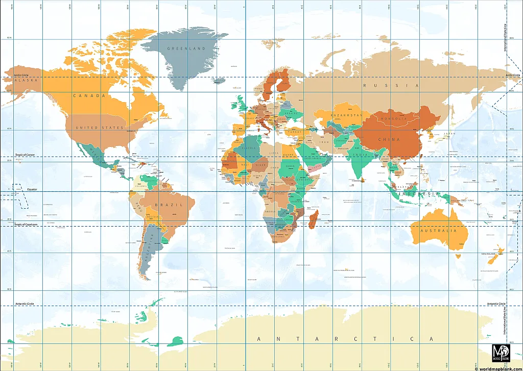
Our first longitude and latitude world map is a Miller projection world map. It also serves as a political world map. We offer PDF files of this map in two different sizes: A4 and A5.
This longitude and latitude map uses the modified Mercator projection introduced by Osborn M. Miller in 1942. It is accurate around the equator but increasingly distorted in the direction of the poles.
Click on the links below the map to directly print the desired version from your browser or save it on your device. You can also download the image.
Additionally, we offer blank world map worksheets for learning activities, country maps, and continent maps. Check them out and enhance your map collection!
Latitude and Longitude Map
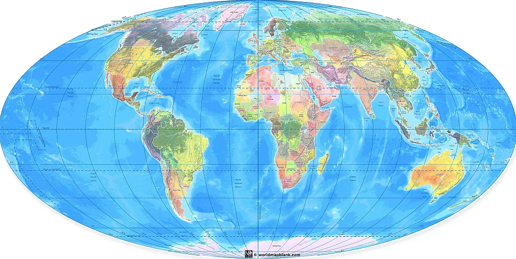
The following latitude and longitude map is based on the Mollweide projection, an equal-area, pseudocylindrical projection widely utilized for world maps or celestial spheres. It emphasizes the accuracy of area proportions over the precise representation of angles and shapes.
Our latitude and longitude map features both political as well as physical characteristics.
Download as PDF (A4)
Download as PDF (A5)
The Mollweide projection was first introduced in 1805 by the German mathematician and astronomer Karl Brandan Mollweide and later, in 1857, reinvented and popularized by Jacques Babinet. The French physicist, mathematician, and astronomer also coined the alternative term “homalographic projection”.
What Are Latitudes and Longitudes?
Latitude lines are imaginary horizontal lines running around the world. They are also known as parallels because they run parallel to each other. Latitude is measured in degrees, with the Equator at 0° latitude and the North and South Poles at 90° latitude.
Longitude lines are the imaginary vertical lines running around the world. They are also known as meridians because they run from the North Pole to the South Pole. Longitude is measured in degrees, with the Prime Meridian at 0° longitude and lines running east or west of it.
What Are Longitudes and Latitudes Used For?
Latitude and longitude lines are an essential part of any world map. Latitude lines run east-west and mark the distance north or south of the equator, while longitude lines run north-south and mark the distance east or west of the prime meridian.
Together, these lines can be used to pinpoint any location on the globe. For example, if someone were looking for New York on a map, they would first find its latitude and longitude coordinates (40.7128° N, 74.0060° W). They would then plot those coordinates on the map, placing them directly over New York City. That way, anyone looking at the map would know precisely where to find it. Latitude and longitude lines are essential to navigation and mapping and allow us to pinpoint any location on Earth accurately.
Map of World with Longitude
The world map below shows the latitudes and longitudes as well as all the countries of the world and the oceans. The degrees for west and east are indicated at the top and bottom of the map. Also, there is a zoom on the political map of Europe.

Map of the World with Latitude
Here is another world map with latitude and longitude lines. It also shows the Prime Meridian with the degrees north, south, east, and west.
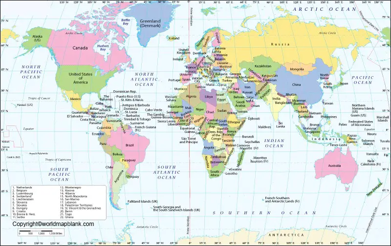
World Map with Longitude and Latitude Degrees Coordinates
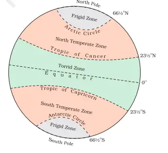
The Equator is an imaginary line that divides the Earth into two hemispheres or equal halves, with one side being the northern and the other the southern hemisphere. The latitude of the Earth’s equator is zero degrees of arc. The equator is one of the five latitudes that have particular names. The other ones are the polar circles (Antarctic Circle and Arctic Circle) and the tropics (Tropic of Capricorn and Tropic of Cancer).

The circumference of the Equator is approximately 24,901 miles (40,075 km).
The country of Ecuador in South America is named after the Equator. Its capital, Quito, is about 25 miles (40 kilometers) south of the equator. This corresponds to just ¼ of a degree. If you want to see where exactly Ecuador is situated, you can find it on one of our South America maps.
World map with Equator and Prime Meridian
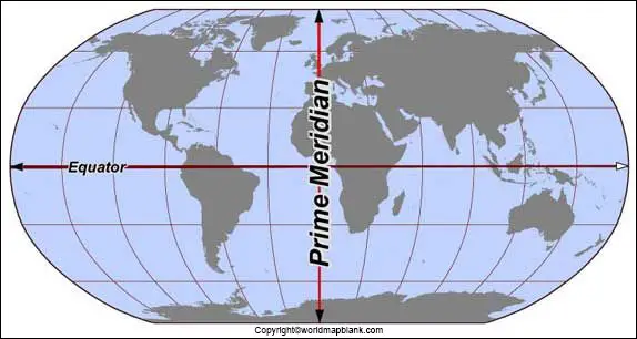
While the Equator divides the planet into the Northern and Southern Hemispheres, the Prime Meridian is another excellent circle that separates the Eastern and Western Hemisphere. The Prime Meridian runs through England and Greenwich and is at zero-degree latitude.
World Map with Equator Tropic of Cancer and Tropic of Capricorn
This world map also shows the Equator, the Tropic of Capricorn, the Tropic of Cancer, the Antarctic Circle, and the Arctic Circle.

The tropics mark the northern and southern latitudes where the sun can be seen 90 degrees above or below the horizon. When the sun is directly overhead one of the tropics on June 21 and December 21, this marks the summer or winter solstice (Northern and Southern Hemispheres, respectively).
World Map with Greenwich Line
The Greenwich Line (or Greenwich Meridian) is an imaginary line drawn through the Greenwich Observatory in London, England. This line is used as the Prime Meridian, or 0° longitude, for all maps of the world. The Greenwich Line was chosen as the Prime Meridian in 1884 because it was already a well-established reference point for maritime navigation.

Around the world, ships would set their chronometers (precision clocks) to GMT (Greenwich Mean Time) before setting out on a journey. This allowed them to calculate their position at sea accurately. Today, although GPS has replaced chronometers for navigation, the Greenwich Line remains the Prime Meridian for maps. Every place on Earth is measured east or west of the Greenwich Line, making it an essential reference point for the geography of our planet.
Download a Free World Map With Longitudes and Latitudes
If you’re looking for a world map with longitude and latitude lines to use as a teaching aid in your classroom, you can download a printable world map for free from this website. All the maps are available in PDF format.
Click on the links below all the images on this page to download your free world map with latitudes and longitudes that you can print. If you need a world map for your school project or presentation, these maps will be helpful. You can use them for teaching, learning, and testing in many ways.
Ideas for Using a World Map as a Teaching Aid in the Classroom
When using a world map as a teaching aid, you can do several different activities with your students. For example, you can have them find specific locations or countries on the map and label them. For this purpose, download our blank map of the world printable. Also, you can use the world map to teach about latitude and longitude lines and how they are used to pinpoint locations on the globe.
Another option would be to create quizzes or games where students have to identify countries or other geographical features based on their coordinates. Alternatively, your students can make geography puzzles after cutting printed maps into pieces. In general, you could discuss in the classroom what makes a good map for different purposes.
If you would like some ready-made but customizable world map worksheets, take a look at our shop!
More Free Maps for Download
We offer a large number of other maps of the world, country maps as well as continent maps. They are all PDF files; you can download, save, and print them for free.
If you need a particular map that you cannot find on our site, please feel free to get in touch with us via our contact form. We can create it for you according to your requirements.
World Maps
- Blank World Map
- World Map with Continents
- Political World Map
- World Map with Oceans and Seas
- Physical World Map
- World Map Poster
- Labeled Map of the World
- World Time Zone Map
Continent Maps
- Blank Map of South America
- Labeled Map of South America
- Blank Map of Asia
- Labeled Map of Africa
- Map of Antarctica with Labels
- Blank Map of Europe
- Labeled Map of Europe
- Blank Map of North America
Country Maps
- Blank Map of the USA
- Map of USA
- US Highway Map
- Labeled Map of China
- Blank Map of Canada
- Map of Germany with States
- Blank Map of Germany
- Map of Australia with States, Capital, and Cities
- Blank Map of the UK
- Blank Map of Mexico
With maps created by:
Olha Bosenko is an expert cartographer and GIS specialist from Ukraine. With a Master's degree from Donetsk National Technical University and further certifications in GIS and cartography, Olha is highly skilled in geographic information systems. She is proficient in ArcGIS Suite and also uses Adobe Illustrator and Photoshop for her map contributions to World Map Blank.


