Labeled Map of Indonesia with States, Capital & Cities
Labeled Map of Indonesia shows that it is an island nation situated in the region of Maritime Southeast Asia. The country is spanning the equator between the South China Sea and the Indian Ocean in the south, and the Pacific Ocean in the north.
- World map with continents
- Physical world map
- Political world map
- Labeled map of Asia
- Labeled map of Africa
- Labeled map of Europe
- Labeled map of Antarctica
- Labeled map of South America
- World time zone map
- Labeled map of world
- World map with longitude and latitude
- Blank map of world
- Labeled map of North America
- Blank map of Asia
- World map with oceans
- World map poster
Indonesia comprise about seventeen thousand islands in the Malay Archipelago. The country’s marine region is also referred to as Spices Archipelago, Indonesian Archipelago, and East Indies; officially recognized as the Republic of Indonesia. Some of the important islands of Indonesia, include New Guinea, Sulawesi, Borneo, Java, and Sumatra.
Labeled Map of Indonesia
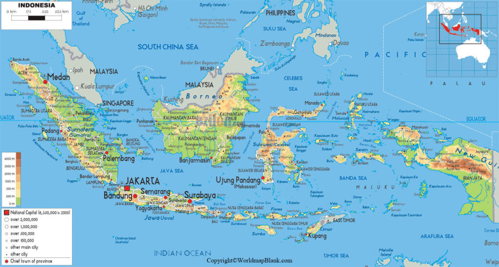
The current updated population figures of Indonesia, in 2020, is 273,713,592. This population is equivalent to 3.51% of the total global population. Indonesia has a total area of 1,919,440 square kilometer. The land area is equivalent to 1,826,440 square kilometer, and water area is equivalent to 93,000 square kilometers.
The largest religion followed is Islam, constituting 87.2% of the country’s total population. The other religions followed in the country, include 0.72% of Buddhist religion, 1.69% of Hindu religion, 9.87% of Christian religion. About 0.56% people practice other faiths.
Labeled Map of Indonesia with States
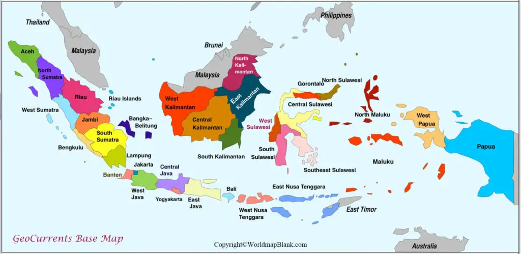
As a part of labeled map of Indonesia with states, one can observe that there are no states in Indonesia. It is a unitary country. Indonesia is divided into thirty-four provinces, out of which three of the provinces are recognized as Special Regions.
The names of these Indonesian provinces are mostly derived out of the combination of the islands, like South Kalimantan, North Maluku, Sumatera, West and East Java. A comprehensive list of Indonesian provinces, includes Sumatera, Java, Kalimantan, Sulawesi, Maluku, Bali, Nusa Tenggara, Papua, Aceh, Riau, Gorontalo, Yogyakarta, Banten, Jakarta, Bangka-Belitung, Jambi, Lampung, and Bengkulu.
Labeled Map of Indonesia with Cities
Through a labeled map of Indonesia with cities, the names of the major cities, include Bali, Jakarta, Surabaya, Medan, Makassar, Bandung, and Batam.
Labeled Indonesia Map with Capital
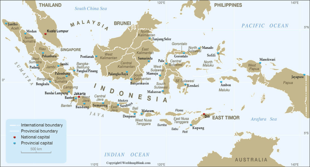
As a part of the labeled Indonesia Map with capital, the Indonesian capital city is Jakarta. However, it may be observed that Indonesia’s capital city is expected to be relocated to the province of East Kalimantan. This is located on the island of Borneo.
However, the current capital Jakarta has thirty million people and is situated on a swampy land. This city of Indonesia is situated on the northwest coast island of Java. It reveals a histrionic mixture of cultures, consisting of Indians and Europeans, Arabs, Chinese, Malays, and Javanese.
These cultures reflect the architecture, languages, and cuisine in the city. Besides, this busy city is famous for the Monas Tower, which is a monument that stands proud in the city. It is considered as a symbol of independence in Indonesia.
It was declared as an independent country in the year 1945 after years of Dutch colonial rule. Even the Dutch colonial buildings exist today in the city. There is an old port in Jakarta city, named Sunda Kelapa where traditional dinghies are docked. Jakarta is also recognized as a special region of Indonesia.
Related Posts


