
🇺🇸 Printable Map of the United States
🇺🇸 Printable Map of the United States
✅ Free download – PDF and JPEG, ready to print.
Download a printable map of the United States for geography teaching, practice worksheets, classroom exercises, homeschooling, presentations, travel planning, and more.
Couldn't load pickup availability
Add multiple maps to the cart to download them all at once.
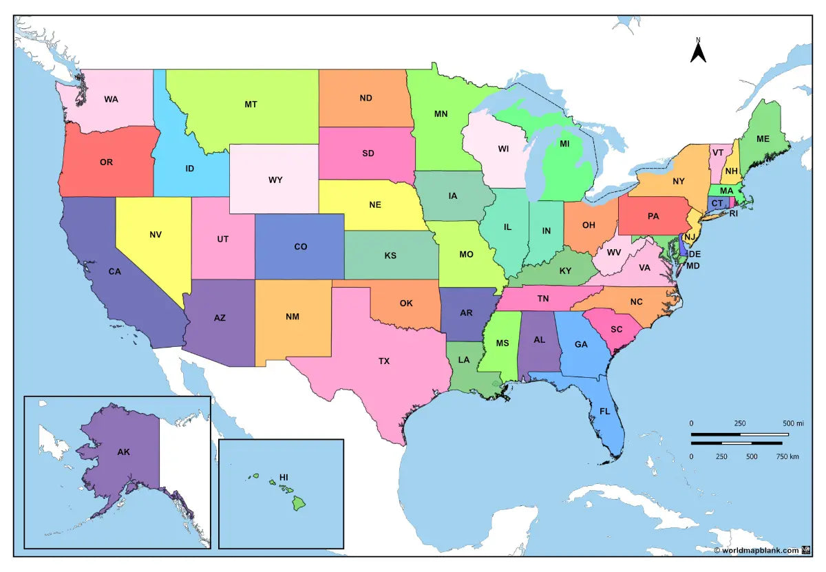
🗺️ Printable Map of the United States with States for Practice, Learning, or Projects
Download your free printable map of the USA with states as a JPEG image and a PDF file. You can also explore our other labeled country maps or use a political map of Canada and a blank map of Mexico for additional regional practice.
Labeled maps are ideal for classroom activities, geography lessons, worksheets, and study projects.
Whether you're looking for a USA map with states, a labeled United States map, or a political map of the USA with cities and capitals, this download offers multiple variations for flexible use.
The image below shows a printable political map of the United States with states, capitals, and major cities. It is included in our USA labeled maps bundle and available in high resolution.

We offer several versions of labeled United States maps for free download and as part of our bundle. Additionally, you can get ready-made but customisable worksheets with U.S. states and capitals as well as blank U.S. state maps.
📁 United States Map Bundle and More
Each file is available in high-resolution PDF and JPEG formats, ready for download and immediate use.
Available styles:
Or get your labeled United States maps bundle, including multiple variations for different learning and reference needs.
- USA map with states (full names)
- USA map with states (abbreviations)
- United States labeled map (full names)
- United States labeled map (abbreviations)
- United States map with states, capitals, and cities
The bundle includes PDF and JPEG versions of all maps.
🌍 U.S. States, Capitals, and Cities
The maps with states and capitals include borders and/or city markers for:
Alabama (Montgomery), Alaska (Juneau), Arizona (Phoenix), Arkansas (Little Rock), California (Sacramento), Colorado (Denver), Connecticut (Hartford), Delaware (Dover), Florida (Tallahassee), Georgia (Atlanta), Hawaii (Honolulu), Idaho (Boise), Illinois (Springfield), Indiana (Indianapolis), Iowa (Des Moines), Kansas (Topeka), Kentucky (Frankfort), Louisiana (Baton Rouge), Maine (Augusta), Maryland (Annapolis), Massachusetts (Boston), Michigan (Lansing), Minnesota (Saint Paul), Mississippi (Jackson), Missouri (Jefferson City), Montana (Helena), Nebraska (Lincoln), Nevada (Carson City), New Hampshire (Concord), New Jersey (Trenton), New Mexico (Santa Fe), New York (Albany), North Carolina (Raleigh), North Dakota (Bismarck), Ohio (Columbus), Oklahoma (Oklahoma City), Oregon (Salem), Pennsylvania (Harrisburg), Rhode Island (Providence), South Carolina (Columbia), South Dakota (Pierre), Tennessee (Nashville), Texas (Austin), Utah (Salt Lake City), Vermont (Montpelier), Virginia (Richmond), Washington (Olympia), West Virginia (Charleston), Wisconsin (Madison), and Wyoming (Cheyenne)
The most detailed U.S. map also contains additional city markers, including:
Akron, Amarillo, Anchorage, Atlantic City, Bakersfield, Baltimore, Beaumont, Billings, Birmingham, Bowling Green, Bridgeport, Buffalo, Casper, Cedar City, Chattanooga, Chicago, Chico, Cincinnati, Cleveland, Cody, Corpus Christi, Dallas, Davenport, Detroit, Duluth, El Paso, Eugene, Fairbanks, Fargo, Flagstaff, Fresno, Grand Forks, Grand Junction, Grand Rapids, Great Falls, Green Bay, Greensboro, Houston, Jacksonville, Jersey City, Kansas City, Knoxville, Las Vegas, Lexington, Los Angeles, Louisville, Lubbock, Medford, Memphis, Miami, Milwaukee, Missoula, Mobile, New Haven, New Orleans, Newark, Norfolk, Oakland, Omaha, Peoria, Pensacola, Philadelphia, Phoenix, Pittsburgh, Portland, Provo, Pueblo, Rapid City, Redding, Reno, Rochester, San Antonio, San Diego, San Francisco, San Jose, Savannah, Seattle, Shreveport, Sioux Falls, Spokane, Springfield, Stamford, Stockton, Syracuse, Tampa, Toledo, Tucson, Youngstown.
✅ Labeled USA Map Features
- Detailed maps with state borders, capitals, and major cities
- Multiple variations with full names and abbreviations
- High-resolution PDF and JPEG formats
- Suitable for education, reference, and study projects
🛒 How to Get Your Printable Map
- Add all your preferred map(s) to the cart
- Proceed to checkout
- Download your maps instantly
🎓 Who It's For
This printable map of the United States with states is ideal for students, teachers, homeschoolers, and travelers. It works well for geography lessons, classroom materials, and detailed regional studies.
Complete your maps collection with a blank USA map or download printable blank U.S. state maps. You can also explore an overview map of the U.S. interstates, educational worksheets, or printable and framed U.S. state wall maps.
Download your labeled United States map now and start using it for learning, teaching, or reference.


Download your free map
Enter your email and tell us how you'll use the map. Your download starts immediately.