Labeled Map of Australia with States, Capital and Cities
A labeled map of Australia with states is a great tool to learn about the geography of this continent, country and big island. Download from this page your Australia labeled map for free and print out as many copies as you need.
Australia is a country located in the southern hemisphere. It is the sixth-largest country in the world after Russia, Canada, China, the United States and Brazil. At the same time, Australia is the world’s smallest continent by landmass and surrounded by the Indian and Pacific oceans. The Australian mainland has six states and two territories, the national capital is Canberra.
The neighboring countries of Australia are Indonesia, East Timor, and Papua New Guinea to the north, the Solomon Islands, Vanuatu, and New Caledonia to the northeast, and New Zealand to the southeast.
Labeled Map of Australia
Our first map of Australia gives a good overview over the main cities, rivers, ports and highways of Australia. It also shows the location of important landmarks such as the Great Barrier Reef, the Great Dividing Range (East Australian Highlands), the Great Victoria Desert and Mount Kosciuszko.
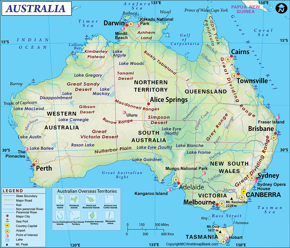
Other natural wonders of Australia include the Uluru (Ayers Rock), the Kakadu National Park, the Twelve Apostles, and the Snowy Mountains.
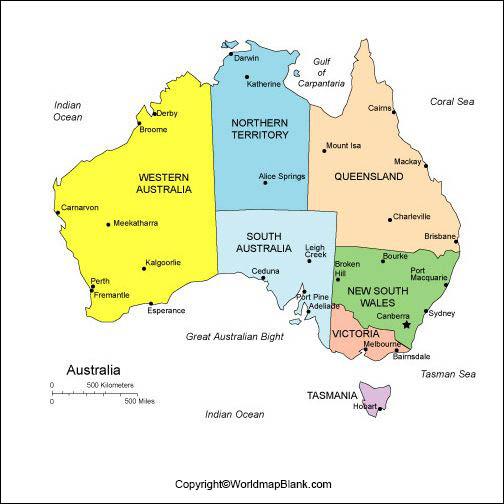
Labeled Map of Australia with States and Territories
The Australian states are Queensland (QLD), New South Wales (NSW), Victoria (VIC), Tasmania (TAS), South Australia (SA) and Western Australia (WA). The two territories are the Northern Territory (NT) and the Australian Capital Territory (ACT).
New South Wales is the most populous state in Australia with a population of over 8 million people. The state capital is Sydney, which is also the most populous city in Australia. Other large cities in New South Wales include Newcastle, Wollongong, Central Coast and Coffs Harbour.
Queensland is the second largest state in Australia with a population of over 5.2 million inhabitants. The state capital is Brisbane, which is also the largest city in Queensland. Other important cities in Queensland include Gold Coast, Townsville, Cairns and Toowoomba.
Victoria is the smallest mainland state in Australia in terms of land area with a population of over 6.6 million people. The state capital is Melbourne, which is also the second largest city in Australia. Other major cities in Victoria include Geelong, Bendigo, Ballarat and Shepparton.
Tasmania is an island state located off the south-eastern coast of Australia with a population of over 560,000 people. The state capital is Hobart, which is also the largest city in Tasmania. Other larger cities in Tasmania include Launceston, Devonport and Burnie.
South Australia is a state located in the southern central part of Australia with a population of over 1.8 million people. The state capital is Adelaide, which is also the fifth largest city in Australia. Other cities in South Australia include Mount Gambier, Whyalla and Port Augusta.
Western Australia is the largest state in Australia with a population of over 2.6 million people. The state capital is Perth, which is also the fourth largest city in Australia. Other major cities in Western Australia include Bunbury, Kalgoorlie and Geraldton.
The Northern Territory is a federal territory located in the central northern part of Australia with a population of approximately 250,000 people. The capital city is Darwin, which is also the largest city in the Northern Territory. Other large agglomerations in the Northern Territory include Alice Springs, Katherine and Tennant Creek.
The Australian Capital Territory is a federal territory located in the south-eastern part of Australia with a population of about 450,000 people. The capital city is Canberra, which is also the seventh largest city in Australia. Other major towns in the Australian Capital Territory include Queanbeyan and Yass.
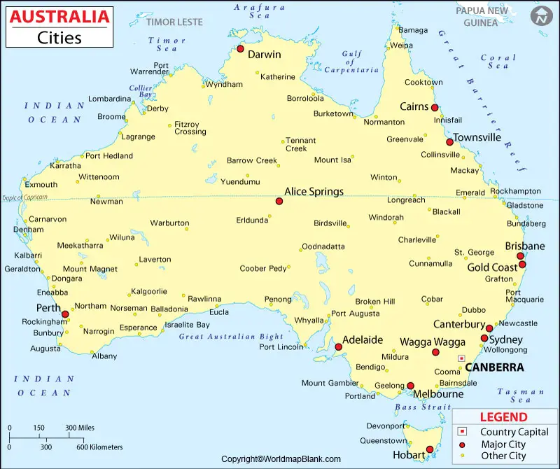
Labeled Map of Australia with Cities
The largest cities of Australia are:
Sydney: With a population of over 5.2 million, Sydney is the most populous city in Australia and Oceania. It is also the state capital of New South Wales. Sydney is a major center for finance, commerce, culture, entertainment, and tourism. The city is home to some of Australia’s most iconic landmarks, such as the Sydney Opera House and the Harbour Bridge.
Melbourne: The second largest city in Australia, Melbourne is the capital of the southeastern state of Victoria. With a population of almost 5 million people, Melbourne is a major center for finance, manufacturing, education, and healthcare. The city is also known for its vibrant cultural scene, with many art galleries and museums.
Brisbane: The capital of the northeastern state of Queensland, Brisbane has a population of over 2.5 million inhabitants. The city is an important area for trade and commerce, as well as tourism. Brisbane is home to many iconic landmarks, such as the Story Bridge and the Wheel of Brisbane.
Perth: The fourth most populous city in Australia, Perth is the capital of Western Australia. With an estimated population of 2.1 million people, Perth is a large hub for finance, manufacturing, education, and healthcare. The city is also known for its beautiful beaches and its vibrant nightlife scene.
Adelaide: The fifth most populous city in Australia, Adelaide is the capital of South Australia. With a population of almost 1.4 million, Adelaide is a major center for finance, education, and healthcare. The city is also known for its many festivals and its vibrant cultural scene.
Gold Coast: The sixth most populous city in Australia, the Gold Coast is located in the southeastern state of Queensland. With a population of 650,000 people, the Gold Coast is an important area for tourism and recreation. The city is home to many iconic landmarks, such as Surfers Paradise and Sea World.
Canberra: The capital of Australia, Canberra is the seventh most populous city in the country. With a population of about 450,000 people, Canberra is an important center for government and politics. The city is also home to many museums and art galleries.
Other important cities in Australia include Darwin, Hobart, Cairns, Townsville, and Alice Springs.
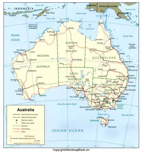
Labeled Australia Map with Capital
The Australian capital Canberra was entirely planned and developed by the American architects Walter Burley Griffin and his wife Marion Mahoney Griffin. It is notable for its unique layout and design.
Canberra is home to many national landmarks and institutions, such as the National Museum of Australia, the National Gallery of Australia, and Parliament House. The city is also home to a number of embassies and diplomatic missions.
Canberra is a major center for education and research, with four universities and numerous research institutes located within its boundaries. The economy of Canberra is largely based on government administration and services, although it also has a significant private sector presence. A number of technology companies have based their operations in the city, and tourism is also an important part of the economy.
More Maps for Free Download and Print
Here is a list of more free printable maps you might be interested in. You can download them all as PDF files and find more via our search bar.
More Australia Maps
Continent Maps
Blank Country Maps
- Blank Map of New Zealand
- United States Blank Map
- Blank Map of France
- Brazil Blank Map
- Blank Map of Belgium
- UK Blank Map
- Blank Map of Egypt
- Bolivia Blank Map
- Blank Map of Finland
Labeled Maps
- Map of India with States and Cities
- Labeled map of South America
- Germany Labeled Map
- Labeled Map of North America
World Maps
Related Posts


