

🇺🇸 Printable U.S. Interstate Highways Map
🇺🇸 Printable U.S. Interstate Highways Map
✅ Free download – PDF and JPEG, ready to print.
Download a printable U.S. interstate highways map for geography teaching, practice worksheets, classroom exercises, homeschooling, presentations, travel planning, and more.
Couldn't load pickup availability
Add multiple maps to the cart to download them all at once.
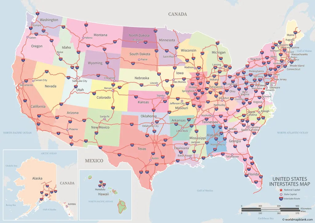
The U.S. Interstate highways map is a printable road map of the United States showing every Interstate route with its shield number, drawn over named and coloured states with the state capitals and Washington D.C. marked. It downloads free as a JPEG and a PDF, with a high-resolution version and a bundle available.
Alaska and Hawaii sit in their own inset panels rather than being left off, and the map carries a legend and a scale bar in both miles and kilometres, so it works for planning a drive as well as for teaching how the network is put together.
It pairs well with our USA geography worksheets, and with the blank map of the USA when you want students to trace the routes in themselves. The same artwork is also available as a 1000-piece jigsaw puzzle.
The image below shows the printable U.S. Interstate highways map with every route numbered.

Which Version Should You Download?
The free map and the high-resolution map are the same map at different sizes. The bundle is a set of five.
| Version | What you get | Best for |
|---|---|---|
| Free Labeled Map | The full Interstate map in JPEG and PDF, free | Printing at A4 or Letter, homework, quick reference |
| High-Resolution Map | The same map at a much larger pixel size, for detailed printing | A3 and up, wall charts, posters, anything where the route shields need to stay sharp |
| Labeled Maps Bundle | Five versions of the U.S. highway and Interstate maps in PDF and JPEG | Getting every variant at once instead of picking one |
The bundle contains:
- U.S. Highway Map
- U.S. Interstate Map
- Interstate Map of the USA
- Highway Map of the United States
- Interstate Map of the United States
The bundle includes PDF and JPEG versions of all the included maps.
How Interstate Numbers Work
The numbering is a system rather than a list, and once you know the four rules you can place almost any Interstate on the map without looking it up.
| Rule | What it means | Example |
|---|---|---|
| Odd numbers run north to south | Numbers rise from west to east | I-5 hugs the Pacific coast; I-95 runs up the Atlantic seaboard |
| Even numbers run east to west | Numbers rise from south to north | I-10 crosses the southern states; I-90 crosses the northern ones |
| Multiples of five are the long hauls | The primary cross-country routes end in 0 or 5 | I-10, I-40, I-70, I-80, I-90, I-95 |
| Three digits belong to a parent route | An even first digit means a loop or belt that returns to the parent; an odd first digit means a spur that does not | I-495 loops around Washington D.C.; I-195 spurs off I-95 |
The system deliberately runs opposite to the older U.S. Highway numbering, where the numbers rise the other way, so that a two-digit Interstate and a two-digit U.S. Route with the same number rarely end up in the same place.
The Longest Interstates
The network covers more than 48,000 miles, and a dozen routes account for a large share of it. These are the ones most trips are built around.
Twelve major Interstates and where they run (click to reveal)
| Route | Runs | Length |
|---|---|---|
| I-90 | Seattle, WA to Boston, MA | about 3,020 miles |
| I-80 | San Francisco, CA to Teaneck, NJ | about 2,900 miles |
| I-40 | Barstow, CA to Wilmington, NC | about 2,555 miles |
| I-10 | Santa Monica, CA to Jacksonville, FL | about 2,460 miles |
| I-70 | Cove Fort, UT to Baltimore, MD | about 2,150 miles |
| I-95 | Miami, FL to Houlton, ME | about 1,910 miles |
| I-75 | Miami, FL to Sault Ste. Marie, MI | about 1,790 miles |
| I-35 | Laredo, TX to Duluth, MN | about 1,570 miles |
| I-20 | Kent, TX to Florence, SC | about 1,540 miles |
| I-15 | San Diego, CA to Sweet Grass, MT | about 1,430 miles |
| I-5 | San Ysidro, CA to Blaine, WA | about 1,380 miles |
| I-25 | Las Cruces, NM to Buffalo, WY | about 1,060 miles |
I-90 is the longest Interstate of all, and I-95 the longest of the north to south routes. I-5 and I-15 are the two that touch both the Mexican and the Canadian border.
About the Interstate Highway System
The Interstate Highway System is the backbone of road travel in the United States, connecting the major cities, the regions and both coasts through a network of controlled-access freeways. It was created by the Federal-Aid Highway Act of 1956 and is formally named the Dwight D. Eisenhower National System of Interstate and Defense Highways, after the president who pushed it through having seen the German autobahns at the end of the war. It now runs to roughly 48,900 miles, about 78,700 kilometres, and carries around a quarter of all vehicle miles driven in the country despite being a small fraction of its road mileage. Texas has more Interstate mileage than any other state and California the heaviest traffic on it. Alaska and Hawaii both have Interstates too, even though neither connects to the mainland network: Alaska's are numbered A-1 to A-4 and Hawaii's H-1 to H-3, and both appear on the insets of this map. Those are the details a route map is consulted for, which is why every primary and auxiliary route is drawn and numbered here.
U.S. Interstate Highways Map Features
- Free version in high-resolution JPEG and PDF, plus a paid high-resolution file and a five-map bundle
- Every primary and auxiliary Interstate drawn and numbered with its route shield
- All 50 states named and coloured, with state capitals and the national capital marked
- Alaska and Hawaii shown in inset panels, with their own Interstate routes
- Legend and a scale bar in both miles and kilometres
- Prints cleanly at A4 and US Letter; use the high-resolution file for A3 and above
- Also available as a 1000-piece jigsaw puzzle
- Suitable for road trip planning, geography lessons, classroom displays and general reference
Frequently Asked Questions
Answers to the questions people ask most about the printable U.S. Interstate highways map.
What do the Interstate numbers mean?
Odd-numbered Interstates run north to south and get higher as you move east, so I-5 is on the Pacific coast and I-95 on the Atlantic. Even numbers run east to west and get higher as you move north, so I-10 crosses the south and I-90 the north. Three-digit routes belong to a parent Interstate: an even first digit means a loop, an odd first digit means a spur.
How long is the Interstate Highway System?
About 48,900 miles, or roughly 78,700 kilometres. I-90 is the longest single route at around 3,020 miles from Seattle to Boston, and I-95 is the longest north to south route at about 1,910 miles.
Are Alaska and Hawaii included on the map?
Yes, both appear in inset panels with their own routes drawn. Alaska has Interstates numbered A-1 to A-4 and Hawaii has H-1 to H-3, none of which connect to the mainland network, which is why they are often left off other maps.
What is the difference between the free map and the high-resolution map?
The same map at a different size. The free version prints cleanly at A4 and US Letter; the high-resolution file is there for A3, wall charts and posters, where the route shields and the smaller city names need to stay sharp.
Is the U.S. Interstate map free to download?
Yes, the standard version is free in JPEG and PDF, with no sign-up. Only the high-resolution file and the five-map bundle carry a small one-off price.
How to Get Your Printable Map
- Choose the version you want above.
- Click "Download now" for the free map, or add the high-resolution version or the bundle to your cart.
- Get your files instantly, then print or annotate them.
Who It's For
Drivers planning a cross-country trip, students and teachers working on U.S. geography, homeschooling parents, and anyone who wants the Interstate network on one printable sheet.
Download your printable U.S. Interstate highways map now and use it for trip planning, learning, or reference.


Download your free map
Enter your email and tell us how you'll use the map. Your download starts immediately.