Germany Postal Codes Map – Germany Map with ZIP Codes [PDF]
On this page, we provide a Germany postal codes map and a Germany map with ZIP codes for free download as PDF files. These maps also include the states and many cities and towns in Germany.
If you need a different Germany map without postal code areas, please check out our Germany map with states. Additionally, we offer a blank map of Germany, which is particularly useful for practicing and memorizing knowledge about the Bundesländer (states), their capitals, and the locations of other major cities in Germany. And, of course, there are our Germany map worksheets with lots of fun and interactive exercises. Check them out!
Postal Codes of Germany Map
Germany’s first postal code system was created in July 1941 to improve the efficiency and accuracy of parcel and general mail deliveries. This first system of ZIP codes in Germany only used two digits.
The main reason for introducing postcodes was the massive number of letters the German military forces sent home. Also, many of the former post office clerks were now fighting in the war and had been replaced by inexperienced personnel. In addition to that, largely unknown or renamed towns in annexed territories had to be added.
Here is our first map with the zip codes of Germany, which also shows the borders and names of the 16 German states. The national capital Berlin and the state capitals are marked with stars, while the map also includes many large cities.
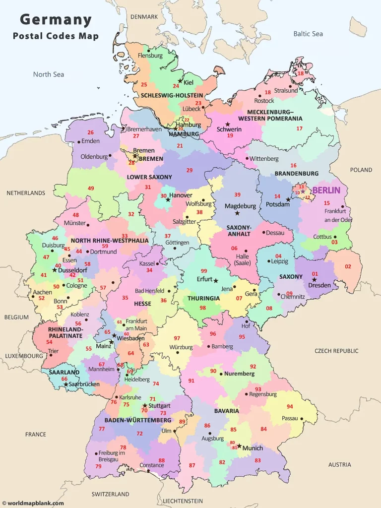
Download as PDF (A4)
Download as PDF (A5)
In West Germany (Federal Republic of Germany), the old postal code system was replaced in 1962 by a four-digit system. This new system was meant to further improve the efficiency and accuracy of mail deliveries. The additional digits facilitated faster and better sorting and delivery of letters and packages. East Germany (German Democratic Republic) still used the old two-digit system until 1965, before it switched to a four-digit system also.
West Germany reserved certain number ranges for the East German postal system to be included in the event of reunification. The starting numbers 1 and 9 were not used for the new zip codes (apart from 1000 for West Berlin). East Germany, however, applied a system from 1 to 9 exclusively for its territory.
Germany Map with ZIP Codes
Our following Germany ZIP codes map is a variation of the first one. The difference is that the one below does not include the names of the German states.
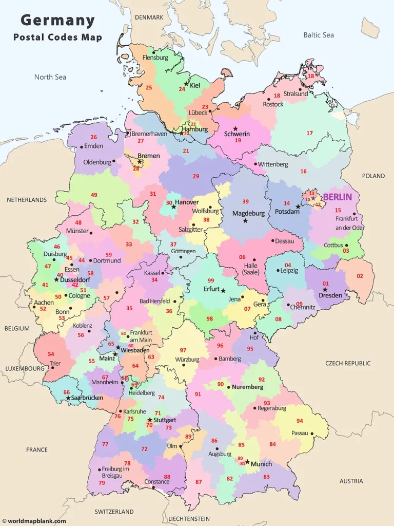 Download as PDF (A4)
Download as PDF (A5)
After the reunification in 1990, two four-digit postal code systems existed with 5420 total codes – 3400 in the west and 2020 in the east. Instead of only changing the 802 duplicate codes, the Deutsche Bundespost (German federal post office) created a new postal code system for the entire country. Even if West Germany had set aside some numbers for the eastern part of the country, the 4-digit system was replaced with a new 5-digit system. This was based on the experience of other European postal administrations, such as France and Sweden.
This new system provided more specific and granular codes that divided larger towns and cities into different areas. It also allowed companies and institutions receiving a large amount of mail to have their own codes. As an example, the Humboldt University of Berlin has the post code 10099, while its street address is assigned 10117. The German parliament (Deutscher Bundestag) uses the zip code 11011.
ZIP Codes of Germany Map
Our following map shows the ZIP code areas of Germany and the German states with names and borders. In addition to the state capitals, many major cities and the neighboring countries of Germany are included as well.
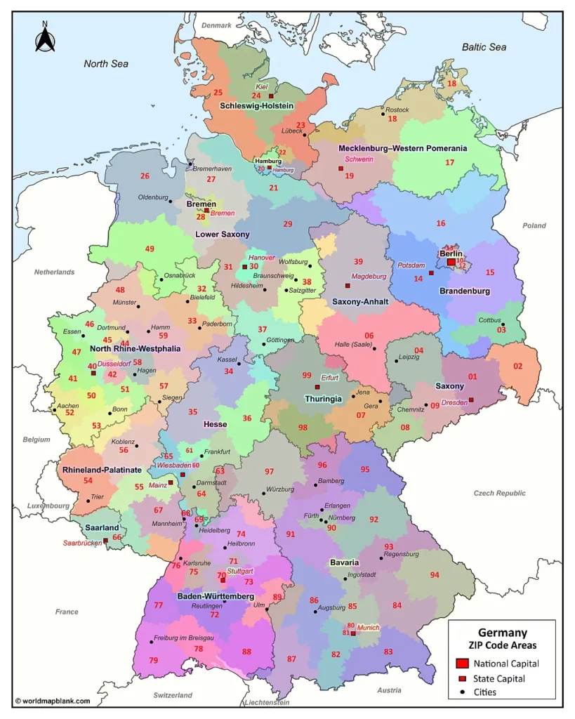
Download as PDF (A4)
Download as PDF (A5)
Today, roughly 30,000 of 100,000 theoretically possible postcodes are used in Germany. Due to certain restrictions, the actual maximum would be 98,901 zip codes.
Postal Codes Germany Map
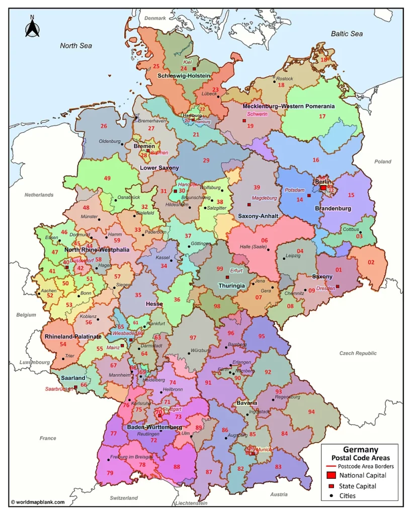
The first two digits of the German postal codes indicate the zone and region of the relevant address. That’s why they are also called the routing region (Postleitregion). Between 20 to 200 numbers are assigned to any given routing region, starting with the main post office and then distributed partly by population size and alphabetically. The lowest numbers are assigned for PO boxes, while the highest ones go to delivery districts.
Today, Germany’s military postal service uses its number of system-based deployment areas.
Download as PDF (A4)
Download as PDF (A5)
Our final Germany map with postal codes above is an alternative version of the previous one. This variation also includes the boundary lines of the 2-digit postal code areas. Note that these are different from the borders between the German states.
More Free Maps of Germany
Here are some links to other maps of or including Germany that we offer for free on our website:
- Political Map of Germany
- Blank Map of Germany
- Europe Map with Countries
- Blank Map of Europe
- Map of the EU
Other PDF Maps for Download
If you want more interesting maps of the world, continents, or single countries, check out the collection below. You can also use the search feature at the top of this page. All our maps can be downloaded for free as PDF files.
World Maps
- Blank World Map
- Political World Map
- World Map for Kids
- Oceans Map of the World
- Latitude and Longitude World Map
Continent Maps
- Map of Africa with Countries
- Blank Map of Africa
- Map of North America
- Blank Australia Map
- Map of Asia Labeled
- Blank Map of Asia
Country Maps
- Map of France with Regions
- Blank Map of France
- UK Map Outline
- Map of Italy with Regions
- Blank Map of Italy
- Map of Ukraine
- Canada Map with Provinces
- Blank Map of Canada
- USA Map with 50 States
- Blank Map of the USA
- USA Interstate Highways Map
With maps created by:
Olha Bosenko is an expert cartographer and GIS specialist from Ukraine. With a Master's degree from Donetsk National Technical University and further certifications in GIS and cartography, Olha is highly skilled in geographic information systems. She is proficient in ArcGIS Suite and also uses Adobe Illustrator and Photoshop for her map contributions to World Map Blank.


