
🇫🇷 Printable Map of France with Regions
🇫🇷 Printable Map of France with Regions
✅ Free download – PDF and JPEG, ready to print.
Download a printable map of France with regions for geography teaching, practice worksheets, classroom exercises, homeschooling, presentations, travel planning, and more.
Couldn't load pickup availability
Add multiple maps to the cart to download them all at once.
Download your free printable map of France with regions as a JPEG image and a PDF file!
Or buy your France labeled maps bundle, including:
🗺 Printable map of France with regions
🗺 Labeled France map with regions and regional capitals
🗺 Political map of France with regions, capitals, and major cities
🗺 Labeled map of France with departments
The bundle includes PDF and JPEG versions of all maps.
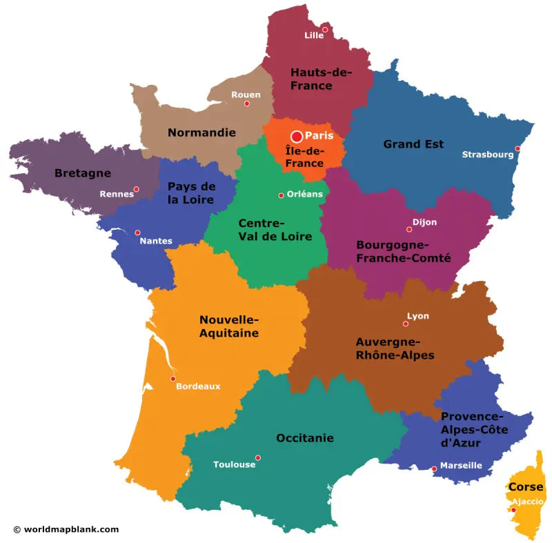
The maps with regions and capitals include borders and/or city markers for:
Auvergne-Rhône-Alpes (Lyon), Bourgogne-Franche-Comté (Dijon), Brittany (Rennes), Centre-Val de Loire (Orléans), Corsica (Ajaccio), Grand Est (Strasbourg), Hauts-de-France (Lille), Île-de-France (Paris), Normandy (Rouen), Nouvelle-Aquitaine (Bordeaux), Occitanie (Toulouse), Pays de la Loire (Nantes), and Provence-Alpes-Côte d’Azur (Marseille)
The map with cities includes additional markers for:
Agen, Ajaccio, Amiens, Angers, Bayonne, Besançon, Bourges, Brest, Brive-la-Gaillarde, Caen, Chambéry, Chalon-sur-Saône, Châteauroux, Clermont-Ferrand, Digne-les-Bains, Épinal, Foix, Guéret, La Roche-sur-Yon, Le Havre, Le Mans, Lille, Limoges, Lons-le-Saunier, Lorient, Mende, Mont-de-Marsan, Montauban, Montluçon, Nevers, Nice, Niort, Périgueux, Poitiers, Quimper, Reims, Rodez, Saint-Étienne, Tarbes, Toulon, Troyes, and Valence
The map with departments includes the following department names:
Ain, Aisne, Allier, Alpes-de-Haute-Provence, Hautes-Alpes, Alpes-Maritimes, Ardèche, Ardennes, Ariège, Aube, Aude, Aveyron, Bouches-du-Rhône, Calvados, Cantal, Charente, Charente-Maritime, Cher, Corrèze, Corse-du-Sud, Haute-Corse, Côte-d'Or, Côtes-d'Armor, Creuse, Dordogne, Doubs, Drôme, Eure, Eure-et-Loir, Finistère, Gard, Haute-Garonne, Gers, Gironde, Hérault, Ille-et-Vilaine, Indre, Indre-et-Loire, Isère, Jura, Landes, Loir-et-Cher, Loire, Haute-Loire, Loire-Atlantique, Loiret, Lot, Lot-et-Garonne, Lozère, Maine-et-Loire, Manche, Marne, Haute-Marne, Mayenne, Meurthe-et-Moselle, Meuse, Morbihan, Moselle, Nièvre, Nord, Oise, Orne, Pas-de-Calais, Puy-de-Dôme, Pyrénées-Atlantiques, Hautes-Pyrénées, Pyrénées-Orientales, Bas-Rhin, Haut-Rhin, Rhône, Haute-Saône, Saône-et-Loire, Sarthe, Savoie, Haute-Savoie, Paris, Seine-Maritime, Seine-et-Marne, Yvelines, Deux-Sèvres, Somme, Tarn, Tarn-et-Garonne, Territoire de Belfort, Val-de-Marne, Val-d'Oise, Var, Vaucluse, Vendée, Vienne, Haute-Vienne, Vosges, Yonne, Territoire de Belfort, Essonne, Hauts-de-Seine, Guadeloupe, Martinique, French Guiana, Mayotte, and Réunion

Download your free map
Enter your email and tell us how you'll use the map. Your download starts immediately.