Printable Map of Italy – Regions of Italy Map [PDF]
Here is our collection of several versions of a general map of Italy, an Italy regions map, and a map of Italy with cities. Download any maps for free as PDF files by clicking the download links below the images. You can choose between A4 and A5 sizes. Save the desired map on your device or print it directly from your browser. Get your Italy map now!
We also offer a map of Italy and surrounding countries and a blank map of Italy. Finally, if you want to teach about the geography and administrative divisions, our Italy map worksheets will be helpful resources. Check them out!
Map of Italy Regions
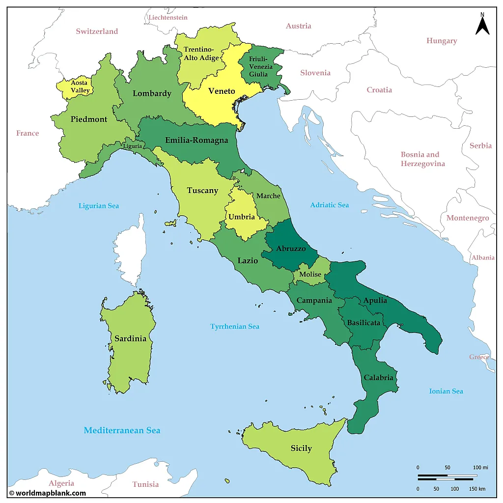
Our first map shows only the regions of Italy without any cities. The neighboring countries of Italy are also included in this map, which helps to understand where Italy is located on a map of Europe.
If you want more resources about Italy’s role in Europe, we recommend our map of the EU page.
Download as PDF (A4)
Download as PDF (A5)
Italy is both part of Southern Europe and Western Europe. It has international land borders with France in the northwest, Switzerland and Austria in the north, and Slovenia in the northeast. There are also two city-states as enclaves within the Italian territory: San Marino and Vatican City.
Italy is a member of the EU and has played a significant role in its evolution, as you can see on our timeline map of the European Union. It is also part of the Eurozone.
Via the Tyrrhenian Sea, Ionian Sea, and Adriatic Sea – all parts of the Mediterranean Sea – Italy also has maritime borders with 10 other countries: Albania, Bosnia and Herzegovina, Croatia, Greece, Malta, Montenegro, Tunisia, Algeria, Libya and Spain.
What are the regions of Italy?
Italy is composed of 20 regions which are the first-level administrative divisions of the country. These regions (regioni) are then divided into provinces (province) and further subdivided into municipalities (comuni).
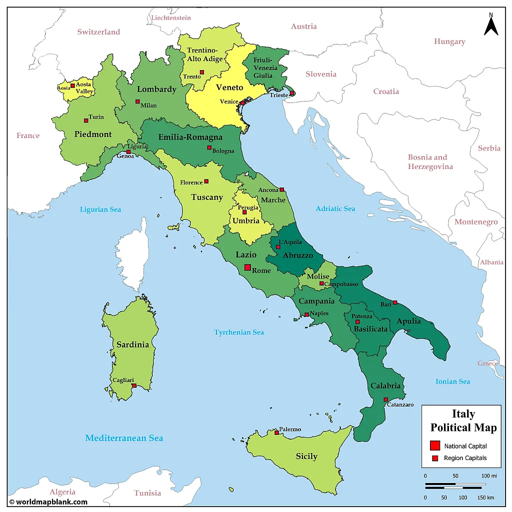
The regions of Italy and their capitals are:
- Abruzzo – L’Aquila
- Aosta Valley (Valle d’Aosta) – Aosta
- Apulia (Puglia) – Bari
- Basilicata – Potenza
- Calabria – Catanzaro
- Campania – Naples
- Emilia-Romagna – Bologna
- Friuli Venezia Giulia – Trieste
- Lazio – Rome
- Liguria – Genoa
- Lombardy (Lombardia) – Milan
- Marche – Ancona
- Molise – Campobasso
- Piedmont (Piemonte) – Turin
- Sardinia (Sardegna) – Cagliari
- Sicily (Sicilia) – Palermo
- Trentino-Alto Adige/Südtirol – Trento
- Tuscany (Toscana) – Florence
- Umbria – Perugia
- Veneto – Venice
Political Map of Italy with Cities
Our following political map of Italy additionally shows all the region capitals in Italy. It also has a scale indicating the distances in miles and kilometers. Finally, the seas around Italy are labeled as well.
Download as PDF (A4)
Download as PDF (A5)
The geography of Italy is very diverse, featuring the majestic Alps in the north, the rolling hills of Tuscany, and coastal areas along both the Tyrrhenian Sea to the west and the Adriatic Sea to its east. The Apennine Mountains extend in various stretches through the entire Italian peninsula.
The country has many large rivers, such as the Po, Adige, and Tiber. In northern Italy, many large lakes exist, such as the famous Lake Como, Lake Maggiore, and Lake Garda. Mountains, quaint villages, and stunning views of nature surround these beautiful lakes.
Italy is also known for its countless islands scattered throughout its waters, with Sardinia and Sicily being among the most popular tourist destinations. Finally, Italy has several active volcanoes, such as Mount Etna, Stromboli, and Mount Vesuvius.
Italy Map with Cities and Regions
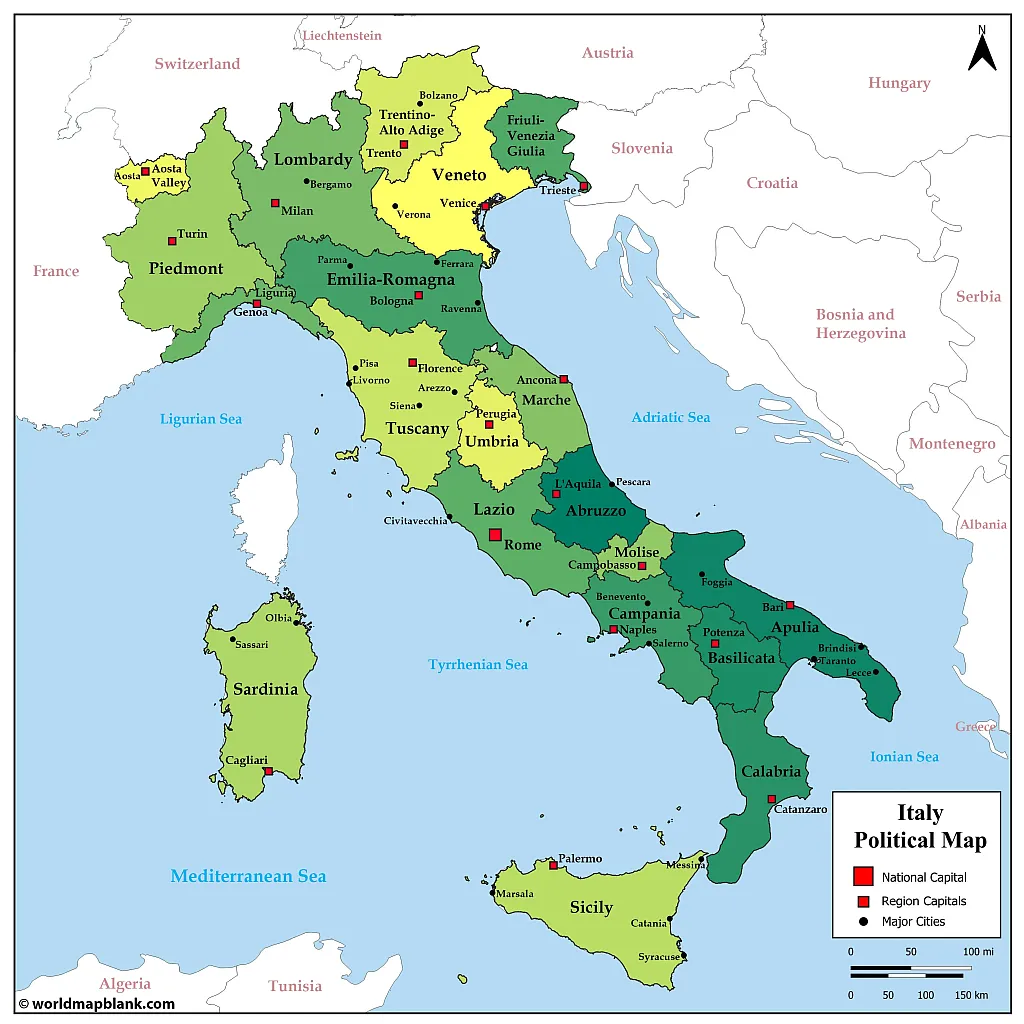
The map below is again a little more detailed. This map of Italy with cities and regions also includes other major cities in Italy apart from the regional capitals.
Download as PDF (A4)
Download as PDF (A5)
To memorize the location of the main cities in Italy, you can combine this map of Italy with major cities with a similar blank map of Italy with cities, including markers for the same Italian cities and towns.
What are the largest cities in Italy?
The capital Rome is by far the biggest city in Italy. Here is a list of the largest cities in Italy by population (in 2022):
- Rome (2.8 million)
- Milan (1.4 million)
- Naples (910,000)
- Turin (844,000)
- Palermo (626,000)
- Genoa (559,000)
- Bologna (392,000)
- Florence (367,000)
- Bari (316,000)
- Catania (296,000)
Map of Italy with Regions and Provinces
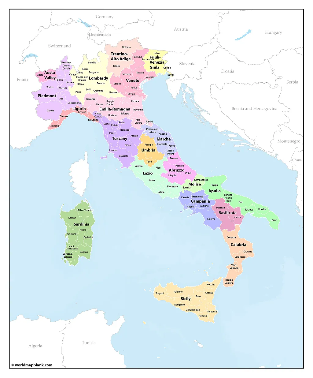
The second-level administrative divisions of Italy are its 107 provinces and 14 metropolitan cities. These are shown in our following map, together with the region names. The neighboring countries are also included, but not the names of the seas surrounding Italy.
Download as PDF (A4)
Download as PDF (A5)
This provinces map of Italy is the most detailed political Italy map we offer. If you want to learn and memorize all the Italian region, city, and province names, check out our various versions of a blank map of Italy.
Map of Italy with Provinces
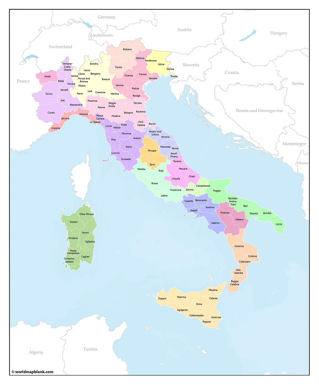
Here is an alternative version of our previous Italy map. This one also shows the provinces but not the Italian region names.
Download as PDF (A4)
Download as PDF (A5)
If you would like a different version of a printable map of Italy, please fill out our contact form. We might already have your desired map available, or we can create it from scratch.
More Free Maps for Download
Below are some links to more maps of countries, the world, and its continents. If the map you need is not listed, please use the search feature in the header menu or send us a message. Any geography resource on our site is free to download as a PDF file. You can print it without limits for personal, educational, or professional needs.
Country Maps
- Italy Map Outline
- Labeled Map of France
- Germany Map with States
- UK Map Outline
- Blank Map of Germany
- Labeled Map of China
- Blank Map of China
- Australia Map with States
- Blank Map of the United States
- Map of Austria with States
- Blank Map of Canada
- Printable Map of USA
Continent Maps
- Political Map of Europe
- Blank Map of Europe
- Blank Map of Africa
- Africa Map with Countries
- Map of South America with Countries
- Blank Map of South America
- Physical Map of Europe
- Blank Map of Asia


