Switzerland Cantons Map – Labeled Map of Switzerland [PDF]
You can download a labeled map of Switzerland for free as a PDF file on this page. With a Switzerland map with cantons, you or your students can easily understand the geography of this European country. Also, you can use our Switzerland maps for professional or personal purposes.
If you need more teaching material about Switzerland, please go ahead and complete your resources with a blank map of Switzerland.
Labeled Map of Switzerland
Switzerland is a diverse and unique country in central Europe, surrounded by Austria, Germany, Liechtenstein, Italy, and France. With a population of around 9 million people (roughly 26% being non-nationals), Switzerland has four official languages – German making up the majority at 65%, followed by French (22%), Italian (8%), and Romansh with 0.6%.
The largest foreign communities from outside Switzerland include Italians (328,000), Germans (310,000), Portuguese (255,000) and French (151,000).
Switzerland has a long history of independence, going back to 1291 when the Federal Charter was signed by the three cantons Uri, Schwyz, and Unterwalden. Over the following centuries, more and more members were added to the Old Swiss Confederacy or Eidgenossenschaft. Today, Switzerland is comprised of 26 cantons.
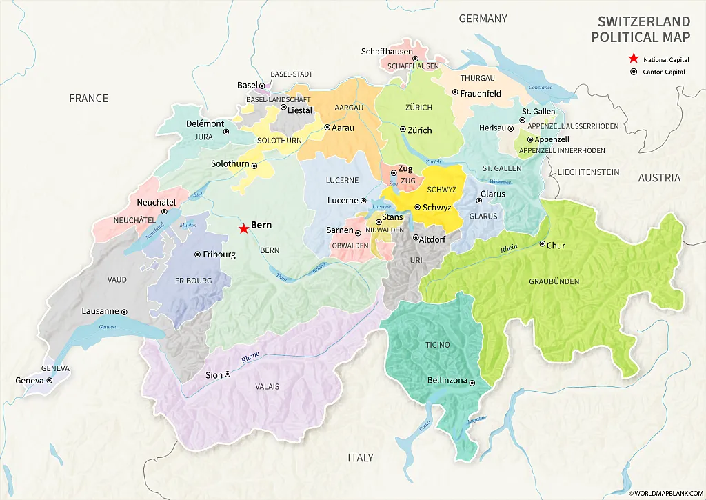
Our first labeled map of Switzerland below shows all the cantons with their names and capitals. Additionally, the neighboring countries of Switzerland, water bodies such as rivers and lakes, and even elevations are shown on the map. Download it in A4 or A5 size by clicking the links below the image.
Download as PDF (A4)
Download as PDF (A5)
Here is a list of today’s Swiss cantons by population (as of 2021):
- Zurich (1.6 million)
- Berne (1 million)
- Vaud (823,000)
- Aargau (703,000)
- St. Gallen (519,000)
- Geneva (509,000)
- Lucerne (420,000)
- Ticino (352,000)
- Valais (353,000)
- Fribourg (330,000)
- Basel-Landschaft (293,000)
- Thurgau (286,000)
- Solothurn (280,000)
- Basel-Stadt (196,000)
- Graubünden (201,000)
- Neuchâtel (176,000)
- Schwyz (164,000)
- Zug (130,000)
- Schaffhausen (84,000)
- Jura (74,000)
- Appenzell-Ausserrhoden (56,000)
- Nidwalden (44,000)
- Glarus (41,000)
- Obwalden (38,000)
- Uri (37,000)
- Appenzell-Innerrhoden (16,000)
Political Switzerland Map
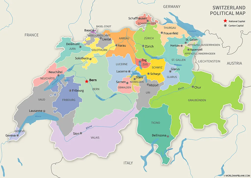
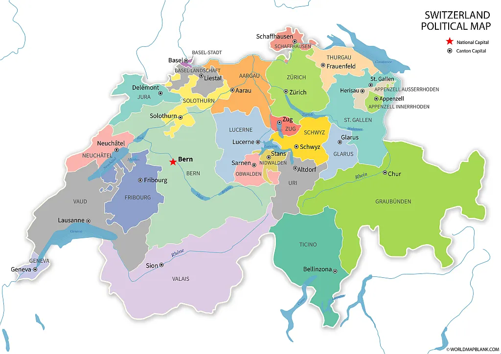
Here is another Political map of Switzerland showing not only the 26 cantons but also their capital cities. The neighboring countries of Switzerland, as well as rivers and lakes, are included. But this map does not indicate elevations.
Download as PDF (A4)
Download as PDF (A5)
Combine any map of Swiss cantons from this page with a Switzerland outline to complete your teaching materials or to improve the learning experience.
If you need a map showing Switzerland in the context of the European continent, try our political map of Europe. However, please remember that Switzerland is not part of the European Union. Therefore, it is not shown as a member state on our map of the EU.
But, of course, Switzerland is included in our Europe map worksheets.
Labeled Map of Switzerland with Cantons
Switzerland has a total area of 15,950 square miles (41,285 km²) and is divided into the three topographical areas of the Swiss Alps, the Swiss Plateau, and the Jura Mountains. The Alps account for 60% of the country’s area, while the majority of Switzerland’s population lives on the Swiss Plateau.
Several major European rivers originate in Switzerland, including the Rhine, Inn, Ticino, and Rhône. Among the more than 1,500 lakes in the country are the famous Lake Constance (called Bodensee in German), Lake Geneva (Lac Léman in French or Genfer See in German), and Lake Maggiore (shared with Italy).
As a country dominated by mountain ranges, Switzerland has numerous high peaks, 48 of which are higher than 13,000 ft (4,000 m). The highest mountains in Switzerland are:
- Dufourspitze – 15,203 ft (4,634 m)
- Dom – 14,911 ft (4,545 m)
- Lyskamm – 14,872 ft (4,533 m)
- Weisshorn – 14,783 ft (4,506 m)
- Matterhorn – 14,692 ft (4,478 m)
Map of Switzerland with Cantons
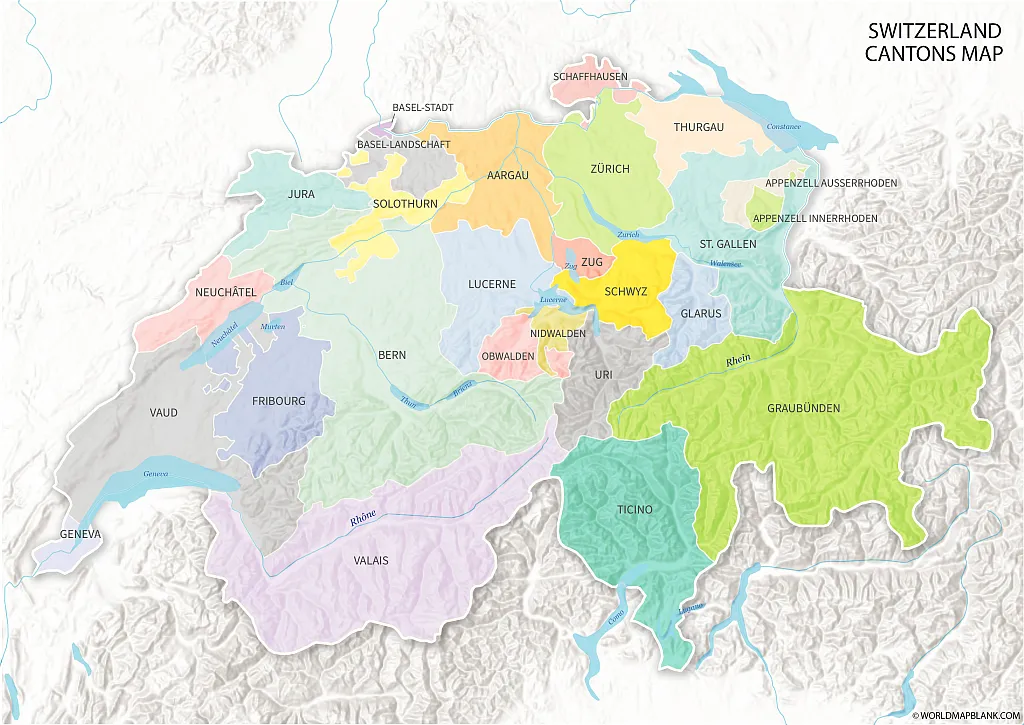
Below, you will find another Swiss cantons map, this time without any cities. However, the relief of elevations in and around Switzerland shows the differences in elevation.
Download as PDF (A4)
Download as PDF (A5)
While Switzerland used to be very rural for centuries, it has developed into a more urban country in modern times.
Switzerland Map With Cities Labeled
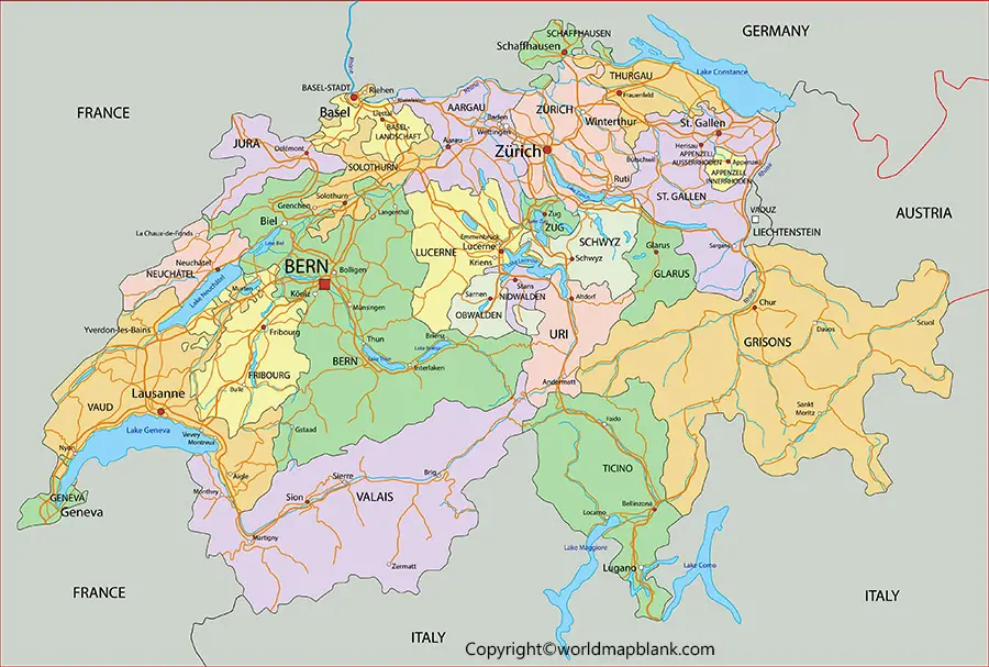
Here is a map of Switzerland with major cities without any canton borders.
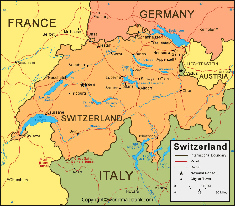
The largest cities and towns in Switzerland by population are (as of 2020):
- Zürich (422,000)
- Geneva (204,000)
- Basel (178,000)
- Lausanne (140,000)
- Bern (135,000)
- Winterthur (114,000)
- Lucerne (83,000)
- St. Gallen (76,000)
- Lugano (62,000)
- Biel (55,000)
Printable Map of Switzerland
Our following map is another cantons of Switzerland map, but this time without any relief or elevations. Both the national capital and the cantons’ capitals are labeled.
Download as PDF (A4)
Download as PDF (A5)
We also provide labeled maps of the neighboring countries of the Swiss Confederation, such as Germany, Italy, France, Austria, and Liechtenstein.
Swiss Cantons Map
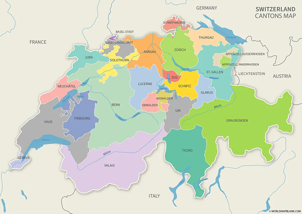
In the following section, you will find several alternative maps of the cantons of Switzerland.
How Many Swiss Cantons Are There?
There are 26 Swiss cantons, 17 of which have German as their official language. Four cantons have French as their only official language, while three use French and German. One canton (Ticino) only uses Italian officially, whereas Graubünden has three official languages (German, Italian, and Romansh).
Download as PDF (A4)
Download as PDF (A5)
The cantons of Switzerland have a very high degree of sovereignty, while only certain areas are governed by the Confederation. These are, among others, the postal service, the army, telecommunication, and the currency. However, every Swiss canton has its own legislature, executive, and constitution, including courts and police.
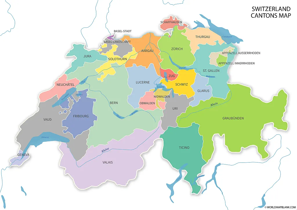
Switzerland Map with Cantons
The largest canton by area is Graubünden (7,105 km²), and the smallest is Basel-Stadt (37 km²). The largest city in Switzerland is Zürich, which was founded by the Romans and used to be an independent city-state in the Middle Ages. It is also the de facto capital of the canton Zürich.
Download as PDF (A4)
Download as PDF (A5)
The capitals of the Swiss cantons are:
- Zurich (Zurich)
- Berne (Berne)
- Lausanne (Vaud)
- Aarau (Aargau)
- St. Gallen (St. Gallen)
- Geneva (Geneva)
- Lucerne (Lucerne)
- Bellinzona (Ticino)
- Sion (Valais)
- Fribourg (Fribourg)
- Liestal (Basel-Landschaft)
- Frauenfeld (Thurgau)
- Solothurn (Solothurn)
- Basel (Basel-Stadt)
- Chur (Graubünden)
- Neuchâtel (Neuchâtel)
- Schwyz (Schwyz)
- Zug (Zug)
- Schaffhausen (Schaffhausen)
- Delémont (Jura)
- Herisau (Appenzell-Ausserrhoden)
- Stans (Nidwalden)
- Glarus (Glarus)
- Sarnen (Obwalden)
- Altdorf (Uri)
- Appenzell (Appenzell-Innerrhoden)
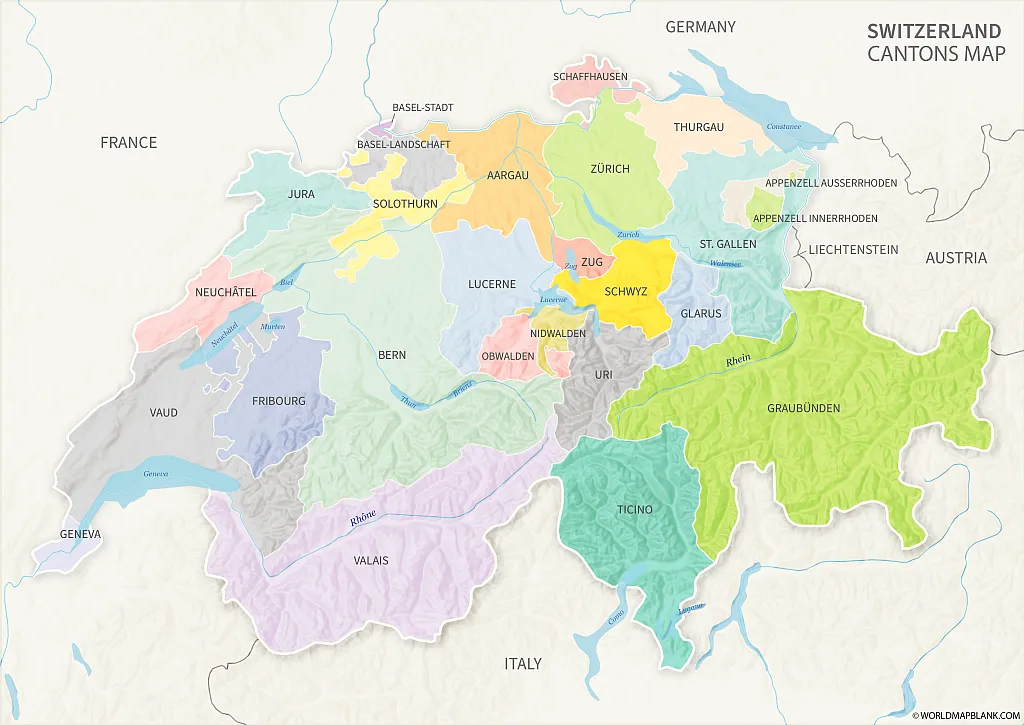
Switzerland Map with Cantons
Download as PDF (A4)
Download as PDF (A5)
The above map shows both the elevations of the landlocked mountainous country and the surrounding states.
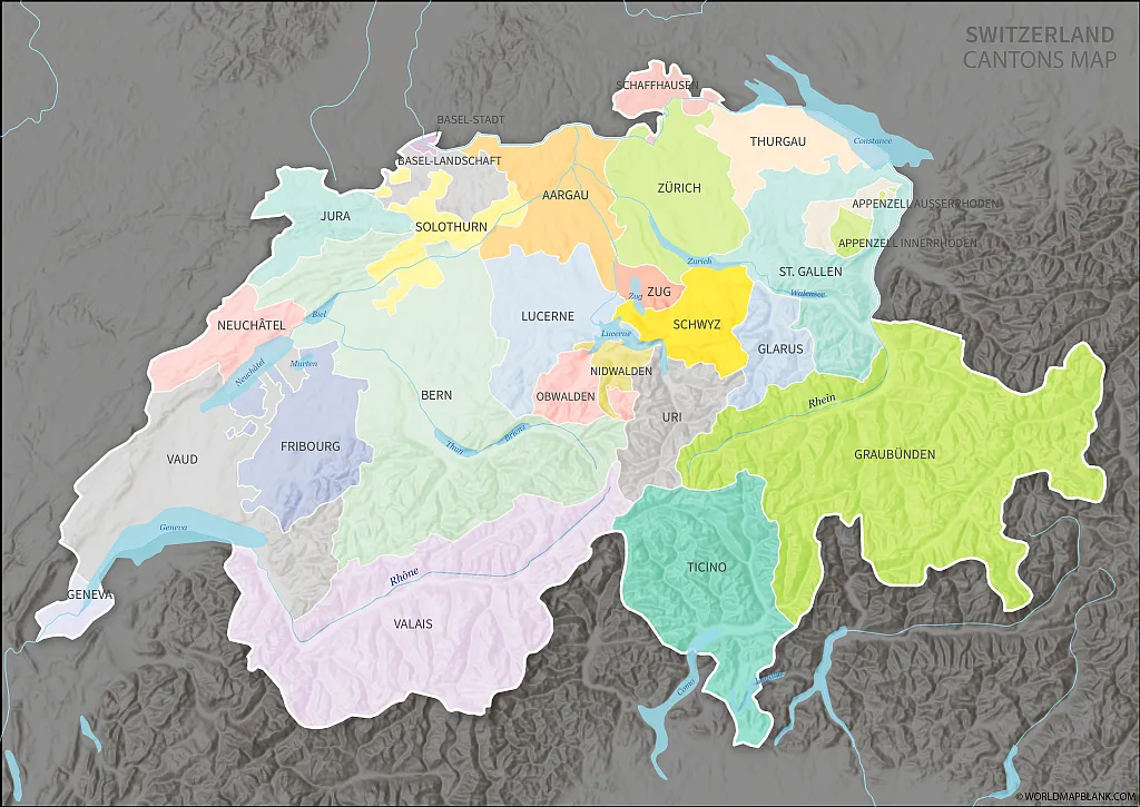
Cantons Map of Switzerland
Our final map with cantonal divisions shows Switzerland highlighted in front of a darkened background.
Download as PDF (A4)
Download as PDF (A5)
Make sure you also check out our outline maps of Switzerland and maps of other countries in Europe and the entire world.
More Free and Printable Maps
Here are a few links to some of our other maps that you can download as PDF files. If the ones you are looking for are not listed, try to find them via our search feature in the header menu. You can also contact us if you need a customized map of Switzerland or any other country or region.
County Maps (Europe)
- Map of Germany with States and Cities
- Blank Map of Germany
- Italy Map with Regions
- Blank Map of Italy
- Map of France with Regions
- Blank Map of France
- Austria Map Blank
- Map of Austria with States
- Blank Map of the UK
Other Country Maps
- Blank Map of the USA
- United States Map with States
- Canada Provinces Map
- Blank Map of Canada
- USA Interstates Map
Continent Maps
- Political Map of Europe
- Blank map of Europe
- Labeled Map of Africa
- Blank Map of Africa
- South America Map with Countries
- Blank Map of South America
- Political Map of Asia
- Blank Map of Asia
World Maps
- Blank World Map
- Map of the World with Latitudes and Longitudes
- World Map for Kids
- Labeled World Map
- Physical World Map
- Political World Map
With maps created by:
Olha Bosenko is an expert cartographer and GIS specialist from Ukraine. With a Master's degree from Donetsk National Technical University and further certifications in GIS and cartography, Olha is highly skilled in geographic information systems. She is proficient in ArcGIS Suite and also uses Adobe Illustrator and Photoshop for her map contributions to World Map Blank.


