Free Blank Map of Denmark with Regions and Cities [PDF]
Are you looking for a blank map of Denmark? You’ve come to the right place! On this page, you will find various free and printable blank maps of Denmark in PDF. Get your outline map of Denmark now!
There are six blank maps of Denmark available. No matter your needs, you can find the perfect Denmark blank map for your purpose. Any of them will help to learn or teach the geography of this fascinating Scandinavian country.
Also, check out our free labeled map of Denmark with regions to complete your resources!
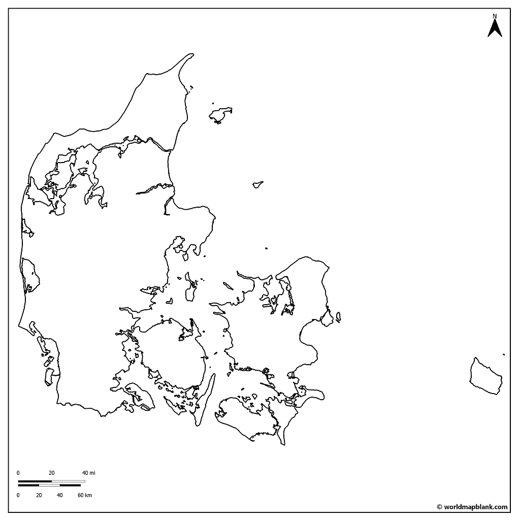
Outline Map of Denmark
Denmark is one of three autonomous constituencies that comprise the Kingdom of Denmark. The other two parts are the Faroe Islands and Greenland. Also, Denmark is part of Scandinavia, sharing close cultural, linguistic, and historical ties with Norway and Sweden. In the broader sense, Finland, Iceland, and the Faroe Islands can be considered Scandinavian countries, too.
Here is an outline map of Denmark only showing its outer boundaries:
Download as PDF (A4)
Download as PDF (A5)
Denmark is the smallest nation in the north of Europe. As of 2023, it has a population of 5,9 million. Nonetheless, Denmark is a very well-developed country with a high standard of living. The country is renowned for its education, health, and government systems. The culture and societal structure have proven in international indexes to come out on top for happiness and productivity levels.
Denmark has taken part in the process towards European unity since 1973, when it joined the European Economic Community. Today, the country is one of 27 member states on the map of the EU.
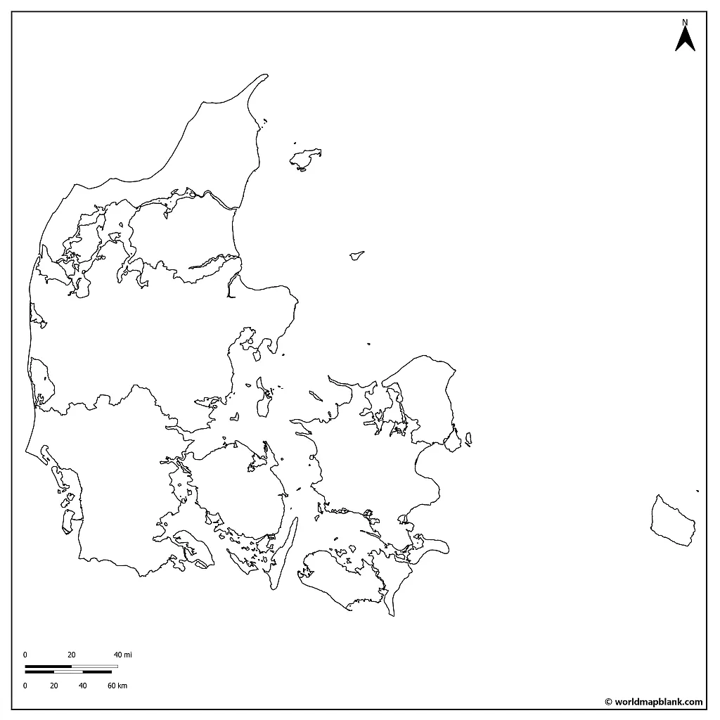
Blank Map of Denmark with Regions
Denmark is divided into five principal regions, which you will find in our next map.
North Jutland, also known as Nordjylland, is the northernmost territory of Denmark. It is famous for some of Denmark’s largest forests, including Rold Skov and Rebild Bakker. The area has many wildlife and bird reserves, making it the wildest of the five regions.
Central Jutland, or Midtjylland, is located in the heart of Denmark. Aarhus is the second-largest city in Denmark, and Herning is known for its textile industry. Aarhus is a cultural hub with numerous museums, galleries, and festivals. Central Jutland is home to Legoland.
Southern Denmark, or Syddanmark, is located in the southern part of the Jutland peninsula and on the island of Funen. It is the second-largest agricultural area in Denmark, with vast fields of wheat, barley, and rapeseed. Known for the iconic Egeskov Castle and the historic towns of Kolding and Ribe.
Download as PDF (A4)
Download as PDF (A5)
Zealand, or Sjælland, is Denmark’s largest island and is home to the capital city, Copenhagen. It has the most diverse landscape of the localities with beaches, farmland, forest, and cityscape. The island is connected to mainland Denmark by several bridges and tunnels. Copenhagen is one of Europe‘s most vibrant and cultural cities, with world-class museums, galleries, and architecture.
The Capital Region, or Hovedstaden, is the smallest of Denmark’s regions but the most densely populated. This region encompasses the Greater Copenhagen area and is famous for its edgy architecture, restaurants, museums, castles, and the royal palace of Amalienborg.
Even though each territory has its unique distinctions, Denmark’s five regions also have common ground regarding geography and characteristics. One of the most impressive is that most of the country lies only 34 meters above sea level, making it one of the lowest-lying countries in the world!
Denmark does not have mountains, with the highest geographic elevation reaching at most 170 meters. The country’s landscape is primarily flat, with rolling hills and sandy beaches found from end to end. This geography lends itself to agricultural production, which thrives throughout the country. In addition to agriculture, manufacturing, fishing, and shipping are the major contributors to the country’s economy.
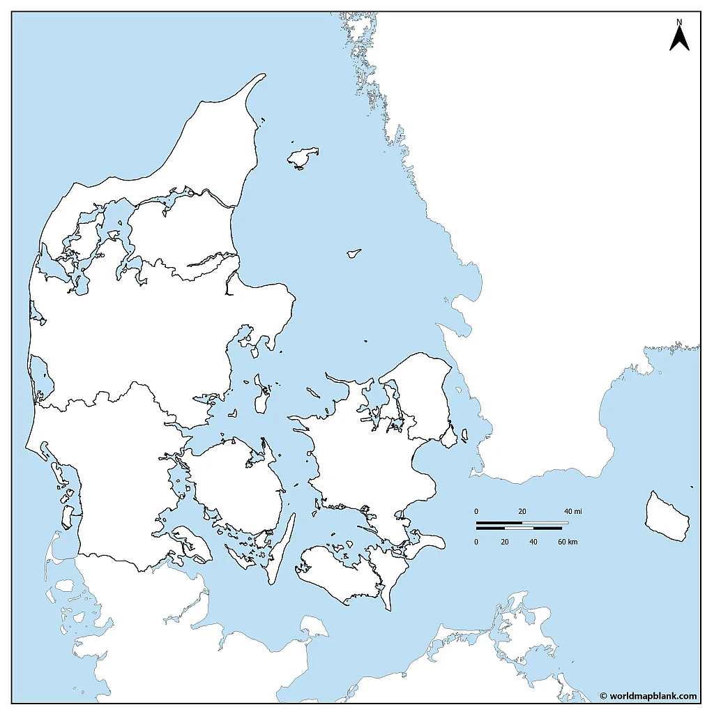
The following map outline is a blank map of Denmark with neighboring countries, which you can use to teach or learn about northern Europe and Scandinavia.
Blank Map of Denmark with Neighboring Countries
Denmark shares one land border with another country, Germany. Historically, the southern part of Denmark and the northern part of Germany have blended, as border lines were drawn and redrawn throughout the ages. Today, there is a large Danish minority in the German state of Schleswig-Holstein and a German minority in the South Jutland.
Download as PDF (A4)
Download as PDF (A5)
Apart from the border with Germany, Denmark is connected to Sweden by a bridge-tunnel across the Øresund Strait in the east. Most of the boundaries of Denmark are defined by water, as seas surround it on three sides. To the west, Denmark is bordered by the North Sea, while the Baltic Sea lies to the east. The Skagerrak Strait, which separates Denmark from Norway, lies to the north.
We also offer a blank map of Norway to enhance your map collection of Scandinavian countries.
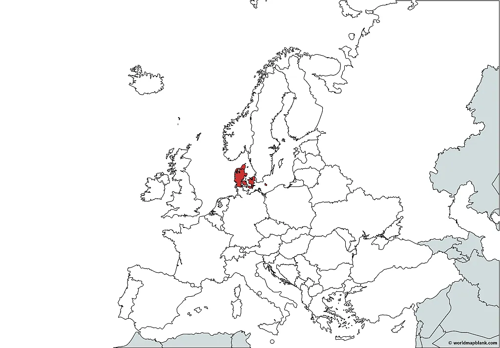
Denmark on Map of Europe
Here is a simple map that answers the question: Where is Denmark on the map? We created it with the help of a tool called MapChart.
Download as PDF (A4)
Download as PDF (A5)
You can use the above map to quickly find out or demonstrate where Denmark is located on a map of Europe. Additionally, you could combine exercises using this map with our Europe map worksheets.
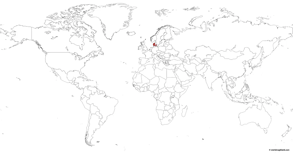
Where is Denmark on the World Map?
Here is a similar printable map of Denmark that shows the location of Denmark on the world map. This map was made with MapChart as well.
Download as PDF (A4)
Download as PDF (A5)
Depending on the definition and source, Denmark is the world’s 131st, 130th, or 133rd largest country. It is similar in size to other European countries like Switzerland, the Netherlands, or Estonia. Compared to US states, this corresponds approximately to the size of Ohio, Virginia, or Tennessee.
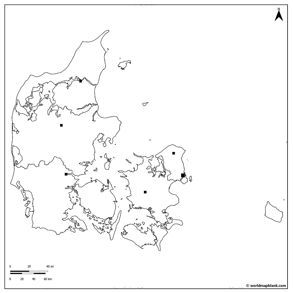
Blank Map of Denmark with Region Capitals
The following outline of Denmark map highlights the region capitals. This is a helpful map when studying the administrative structure of the country.
Listed below are the capitals of the five regions of Denmark and their population as of 2022:
- Aalborg (North Jutland) – 216,091
- Aarhus (Central Jutland) – 353,845
- Odense (Southern Denmark) – 205,225
- Copenhagen (Capital Region) – 633,565
- Roskilde (Zealand) – 56,291
Download as PDF (A4)
Download as PDF (A5)
An empty map can be filled with a lot of information. For example, you or your students can use a Denmark blank map to learn the location of the main cities or the names of rivers, landmarks, and other features. Simply download it, print it, and use it for any learning activities in the classroom or at home.
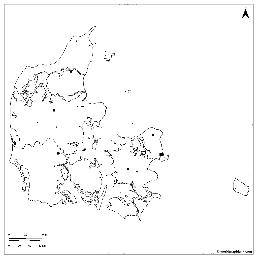
Blank Map of Denmark with Cities
Our next and final Denmark outline map is also our most detailed one. It includes some larger cities and towns besides region borders and capitals.
Download as PDF (A4)
Download as PDF (A5)
All cities and towns of Denmark have their own personalities based on their location, the primary industry, and their population, of course. Below, you can find out something about each city, as they are grouped by their regions.
North Jutland:
- Frederikshavn: fishing industry, gateway to Læsø
- Aalborg: fourth largest city, nightlife, Aalborg Zoo
Central Jutland:
- Hirtshals: fishing port, ferry terminal to Norway and the Faroes
- Viborg: Viking Age history, Viborg cathedral
- Aarhus: second largest city, cultural scene, old town, Viking museum
- Vejle: fjord, gateway to Legoland
South Denmark:
- Kolding: historic town, Koldinghus Castle, old town
- Odense: third largest city, Hans Christian Andersen’s birthplace, museums
- Esbjerg: fishing industry, gateway to Wadden Sea National Park
Zealand:
- Hillerød: Frederiksborg Castle, Danish Museum of National History
- Roskilde: Roskilde Cathedral, annual Roskilde Festival
- Copenhagen: national capital and largest city, with beautiful architecture, museums, and Tivoli Gardens
Capital Region of Denmark:
- Helsingør: Kronborg Castle, inspiration for Shakespeare’s tragedy “Hamlet”
The Denmark country outline maps are great for anyone who wants to know more about this small but mighty Scandinavian country.
More Free PDF Maps for Download
Check out the links below to more geography sources, such as maps of European countries, continent maps, or world maps. If your desired map is not available, please get in touch with us, and we will do our best to create it for you. Also, remember to use the search function in the header menu to find more valuable maps!
Additionally, check out our map worksheets for interactive learning activities!
Country Maps
- Germany Map with States
- Blank map of Germany
- Blank Map of France
- Labeled Map of China
- Blank Map of China
- Australia Map with States
- Blank Map of the United States
- USA Map with all 50 States
- Labeled Map of Italy
- Outline Map of Italy
- Blank Map of Canada
- Provinces of Canada Map
Continent Maps
- Political Map of Europe
- Blank Map of Europe
- Blank Map of Africa
- Africa Map with Countries
- Blank Map of Africa
- Map of South America with Countries
- Blank Map of South America
- Physical Map of Europe
- Blank Map of Asia
World Maps
- Blank World Map
- World Map for Kids
- Oceans Map of the World
- Political World Map
- World Map with Latitude and Longitude
- Physical World Map
- World Map with Continents
With maps created by:

Edelweise Shane Angeles is a skilled GIS Analyst and Cartographer from Davao City, Philippines. Holding a Bachelor's in Geology and Earth Science, he specializes in creating practical, clear maps using tools like Global Mapper, ArcGIS, ArcMap, and Google Earth Pro. Edelweise creates both blank and labelled maps for World Map Blank.
Related Posts


